High Dune Hike: The Essential Trail at Great Sand Dunes National Park


Great Sand Dunes National Park is a place where vast dune fields stretch out before you, framed by patches of greenery and scrub, all set against the backdrop of towering, snow-capped mountain peaks.
To truly appreciate the scale of the dunes, one has to step into them. The hike to High Dune is the perfect introduction to the vast dunefield at Great Sand Dunes National Park, offering a balanced mix of effort and reward and panoramic views of the rolling sand dunes below and the snow-capped Sangre de Cristo Mountains beyond.
In this article, I’ll take you on a hike into the dunefield, share what I learned along the way, and cover everything you need to know to plan your own visit to Great Sand Dunes National Park.
Settle in, grab a cup of coffee, tea, or whatever helps you get cozy — and let’s get started!
At A Glance: Nature at Great Sand Dunes
How Did the Dunes Form?
The dunes formed over thousands of years from sand and sediments that were once part of ancient lakes and rivers in the San Luis Valley. Prevailing southwesterly winds pushed sand toward the Sangre de Cristo Mountains, while seasonal storm winds from the east helped trap it. This unique combination created North America’s tallest dunes, rising up to 750 feet.
How Much Do The Dunes Change Over Time?
The dunes are a dynamic system that continues to evolve, shaped by wind, water, and time. Though the dunes are constantly shifting, their overall shape and position have remained relatively unchanged for at least 138 years!
Dune Ecology & Surrounding Habitats
- Diverse Habitats: The park includes not just dunes, but also grasslands, shrublands, wetlands, forests, and alpine tundra.
- Water Sources: Seasonal creeks like Medano Creek support wetlands and are essential for amphibians and migratory birds.
- Adapted Species: Several species are endemic to the dunes, meaning they’re found nowhere else on Earth. One example is the Great Sand Dunes tiger beetle.
- Vegetation: Plants like blowout grass and scurfpea help stabilize the sand and support the food web.
Source: National Park Service: Nature & Science at Great Sand Dunes
Climbing High Dune: Footprints That Fade, Lessons That Last
The tent opened with the familiar zip, and fresh air rushed inside. The cool, desert-scented breeze brushed our faces. Around us, the entire campground was blanketed in silence; just a light snore from a tent here and there carried by the wind. While crawling back onto the air mattress was tempting, we had a different plan this morning: hiking up to the aptly literal ‘High Dune’ in the vast dunefield that stretched out below us: a landscape we had been admiring since last night from our campsite. Just some bushes and a bit of elevation separated us from the wind-sculpted beige waves.
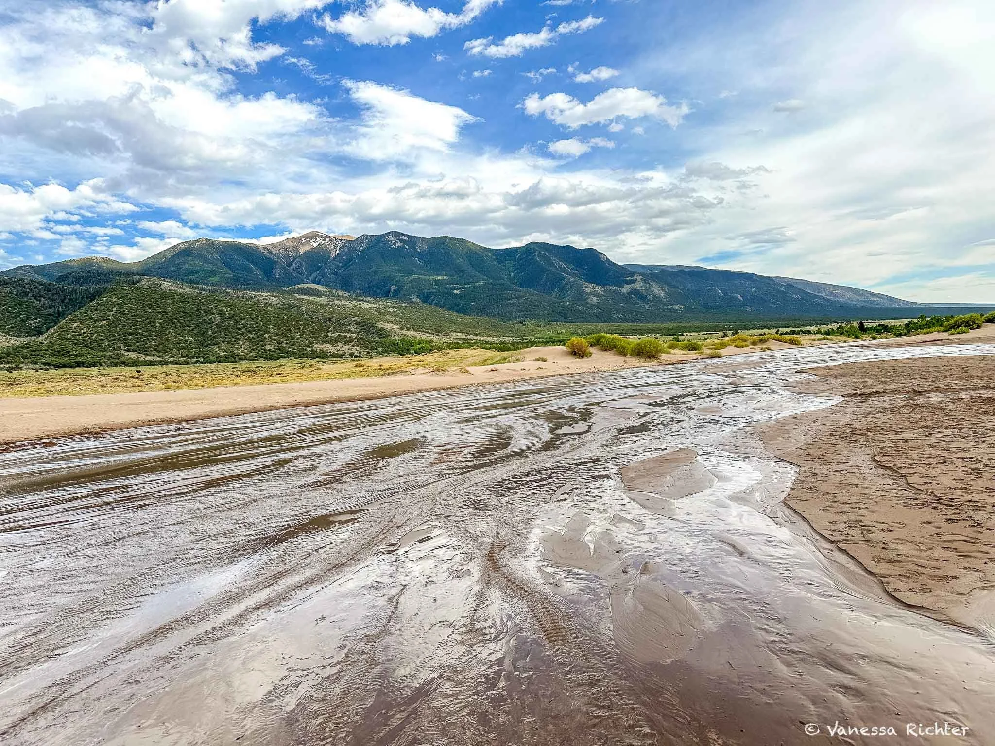
We got ready quickly and started making our way down to the dunes. Our footsteps were the only sound, periodically changing with the surface beneath our feet. Soon, the hollow sound of walking on asphalt gave way to the crunch of gravel. The gravel turned into sand, and with that, silence replaced the crackling of small stones. We removed our shoes, and the cool sand stroked our feet. We headed farther toward the piled-up dunes, where, at the base, the fluffy grains were drenched in water — a stream was flowing across the foot of the dunes. A surge of water caused it to rush up in pulses. The stream was wide, but the water level just barely covered our feet. Soon, the stream bed would dry up again, once the snow in the Sangre de Cristo Mountains flanking the dunes had fully melted. On this early June morning, though, the melt was still in full swing, and the giants behind us still wore their white caps. After crossing the seasonal stream, only sand as far as the eye could see lay ahead. Like a painting, the sand formed a sea of hills, its curves, shapes, and shadows flowing seamlessly into one another.
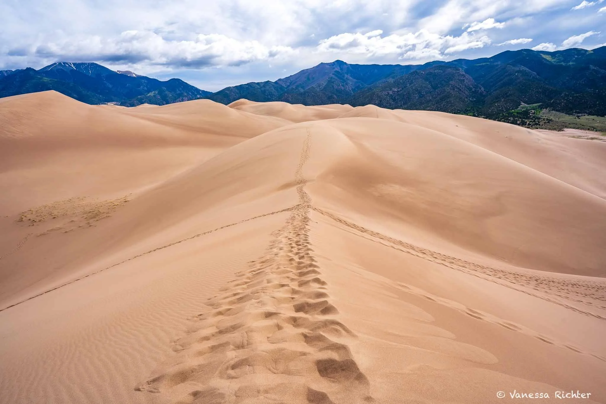
What had looked gentle from the campsite quickly revealed itself as a grind. Each step slid backward, the sand giving way under our weight, draining our calves faster than any rocky trail ever had. Distances that would normally pass unnoticed suddenly demanded focus and patience. After we made it up the first significant dune, we let ourselves fall into the sand and enjoyed breakfast with a view of the mountains and dunefield. While the peacefulness of sitting in the sand — combined with the mild annoyance of trying to keep tiny sand grains out of our food — is an “activity” I could have kept doing for much longer, I also really wanted to get further up and explore new angles. The nonexistent trail led us onward along a narrow ridge: some sections flat, followed by grueling uphills once again.
It was fascinating to see that, even though footsteps disappeared quickly in the sand and there was no clear path, most people seemed to have chosen the same route we did. It turned out to be a good on with not many unnecessary downs, which would have meant even more ups. Instead, the route involved mostly climbing up, with some flat stretches that gave us a break from the steeper parts. Along the way, our sense of distance gradually adjusted, and we became more attuned to the unique rhythm of hiking on sand.
Every now and then, a fellow hiker would comment on how much more strenuous uphill sand hiking is. And after a mix of climbing, walking flats along the ridge, and more climbing, we finally reached the destination of our hike: a viewpoint high enough above the dunefield to feel fully immersed, with beautiful patterns of dunes below us and the snow-capped mountains and greenery stretching across the horizon. We took in the surreal view for a while, admiring puffy clouds scattered across the blue sky above and warm beige hues beneath our feet. Dunes, mountains, trees, and endless skies as far as the eye could see.
By the time we started descending, the dunes had left their mark. Each step on the soft sand felt like a negotiation with gravity: progress measured in effort, not distance. Behind us, the wind and pull of the sand hurried to erase the proof of the climb.
The dunes had made something clear: the ground beneath your feet shapes the weight of the journey. Effort can’t be judged from afar. Yet, there is one thing that is universally true. Every journey is defined by this simple truth: putting one step in front of the other.


Hiking High Dune: Trail Details
📍 Distance: 3.0 mi (4.8 km)
⛰ Elevation Gain: 603 ft (184 m)
🔙 Route Type: Out & Back
High Dune stands out—not as the tallest or highest in elevation, but for its breathtaking views, accessibility, and the illusionof towering above the rest when viewed from the main parking lot. Rising about 692 feet (210 m) from base to top, reaching the first ridge rewards with stunning panoramas of the dunefield and the surrounding landscape.
While navigation apps can provide a rough idea of where to walk, there’s no set trail on the dunes. Footprints quickly vanish in the wind. However, the paths most people take serve as good indicators of the most reasonable routes. If you stay at Piñon Flats Campground, you can start the hike directly from your campsite.
🥾 Hiking On Sand Is No Joke
The High Dune trail is deceptively demanding — soft sand shifts underfoot with every step, the terrain is completely exposed, and the sun reflects off the dunes with surprising intensity. I've put together a full list of what I bring: the pack that keeps my back cool in the heat, solid sun protection, lightweight hydration, and the small things (including my camera setup) that I genuinely wouldn't leave without.
→ Explore My Tried-and-True Hiking GearThere are other hikes to different dunes, but High Dune one hits the sweet spot for effort and views — and honestly, they couldn’t be better. However, if you’d like to extend the hike, you can continue on to Star Dune, the second-tallest dune in North America at about 736 feet (more direct access is via its base along the Medano Creek bed, without hiking to High Dune first, though). Or, for a more remote adventure, consider tackling Hidden Dune, a 741-foot giant, making it the tallest dune in North America.
Know Before You Go
Best Time to Visit
- Spring: Mild temperatures and a seasonal stream (Medano Creek) — perfect for hiking. Medano Creek typically flows from late April through early June, with peak flow occurring in late May.
- Summer: Air temps average in the mid-70s, but the sand can be brutally hot. Thunderstorms are possible in July and August, so plan for early hikes. Expect more crowds.
- Fall: Cooler weather and fewer visitors make this a great time to explore.
- Winter: Quiet, cold, and potentially snowy. A magical time to see dunes dusted in snow!
Tips For Spring, Summer & Fall
- Start Early for Cooler Sand: The sand heats up fast under the sun even when air temperatures are mild — by midday, it can get too hot to walk on barefoot. Heading out early means cooler sand and more comfortable hiking.
- Hiking Barefoot: I personally loved hiking this trail barefoot—no shoes full of sand, and it’s nice to feel the soft sand beneath your feet.
Access & Campground
- Best Access: Staying at Piñon Flats Campground offers the most convenient access to the dunes — you can start the hike right from the campground without driving.
- Trail Conditions: Hiking on sand is tough! Even short distances can feel exhausting, and it's definetly a workout for your calves. This 3-mile sandy hike with moderate elevation did feel harder to me than many longer and steeper trails!
On My Bucket List
- Camping in the Dunes: With a permit, you can spend the night right in the dunes — something I imagine is absolutely magical for stargazing and Milky Way photography.
- Night Hike: Walking the dunes under moonlight is on my list too. If you've done it, I'd genuinely love to hear what it was like!
Read On for More Colorado Adventures & A Complete Road Trip Including Great Sand Dunes


Follow the Adventure
Latest on the Blog

Search
What could be more breathtaking than a road trip from California’s rugged Pacific coast across Utah’s deep red deserts to Colorado’s rushing mountain rivers in late spring? Imagine yourself traversing the vast, sun-scorched deserts along the Loneliest Road in America, gazing into the universe under some of the world’s darkest skies, hiking the tallest sand dunes in the Northern Hemisphere, and admiring turquoise alpine lakes while looking down at bone-dry deserts stretching endlessly below. In this article, I’ll take you through my absolute favorite outdoor adventures on a three-week road trip spanning California’s coastline, Utah and Nevada’s wild landscapes, and Colorado’s Rocky Mountains.