Hiking Cinder Cone in Lassen Volcanic National Park: Painted Dunes, Lava Beds, and the Small Wonders Along the Way
This post contains affiliate links. If you book through them, I may earn a small kickback at no extra cost to you, which helps me write free resources like this one — thank you for supporting my blog.
The Cinder Cone Trail sits in the northeastern corner of Lassen Volcanic National Park, in an often overlooked part of California. The hike climbs a volcano that erupted 350 years ago, with a crater you can walk into at the top and a panorama of red volcanic dunes laid out below. The climb itself is hard: loose scoria sliding under your boots, no shade, dark ground throwing back the heat, but the reward is one of the most surreal landscapes I've seen.
What I didn't expect was how much else there was to notice along the way. Flowers blooming out of nothing but volcanic gravel. A forest with no understory. A view from the rim that includes all four different kinds of volcano; one of which doesn't look like a volcano at all anymore.
This article is about what I found hiking the Cinder Cone Trail in July, both the postcard view and the smaller things hidden in plain sight if you take the time to look.
📋 In This Article
- Hiking Cinder Cone: Painted Dunes, Fantastic Lavabeds & The Small Details Along The Way
- Trail Details
- A Forest With No Understory
- A Short, Loud Life
- Wildflower Spotlight: Sulfur Buckwheat
- Painted Dunes, Lassen Peak And The Ghost Of A Bigger Volcano
- The Park Built By Four Different Volcanoes
- The Naturalist's Kit
- Know Before You Go
Hiking Cinder Cone: Painted Dunes, Fantastic Lavabeds & The Small Details Along The Way

Scan for map & details
📏
4.7 mi
7.6 km
Distance
⛰
1,095 ft
334 m
Elevation
🔄
Loop
Route
A Forest With No Understory
A loud high-pitched sound cut through the chilly morning air. Half asleep, I fumbled for my phone and silenced it. Now the campground was blanketed in silence again. No chirping birds, campfires, or squirrels racing up the trees just yet, with everything covered in moonless darkness. I felt dizzy with tiredness and the warm sleeping bag wrapped around me like the coziest cocoon. Still, the plan for the day was already buzzing in my head and pulling me out of the warmth into the morning chill. Zipping the tent open let in a rush of fresh air.
Soon, we found ourselves passing tents filled with light snores, parked RVs and camping chairs still empty. The crunch of the sandy ground beneath our feet was the only sound, the air holding its breath. The stars had started to fade with the sun pushing gently up toward the horizon. Even though the temperature prompted us to zip up our sweaters, I could tell the day was going to be warm.
Once we had left the campground, Butte Lake came into view, lying perfectly still in front of us. Just a few hours ago, the lake had turned into a mirror reflecting the sparkles of the star-filled sky and the Milky Way. Now, its surface was covered in low-lying tufts of mist, like cotton candy resting on the water. The puffy clouds would burst under the first rays of sun, as if they'd never been there.
At the tip of the lake, we reached the trailhead, where the hike officially started. The forest here seemed ordinary and strange at once. Tall pine trees lined the trail, needles and cones covering the ground. We had seen countless squirrels roaming the campground, woodpeckers hammering into the bark of trees and even a toad camouflaging well with the vegetation near the lake the day before. Just regular features of an ordinary forest. However, that wasn't all. I looked at the ground: beneath my hiking shoes, gravelly pieces of ashy sand mixed with needles of evergreen trees. At the trail's edge, the trunks of some trees were charred black from a wildfire; elsewhere, a fallen one stretched across the ground. But the shrubby understory, the occasional herbaceous shade-tolerant plant pushing through the sea of needles: none of it was here.
We continued our walk, reminding ourselves not to get too comfortable; the climb was still ahead, hidden behind all the pines. I had read in reviews for the trail that people had seen bears, including a mama bear with cubs, so I kept looking left and right. I was hoping to see one, with a healthy dose of caution at the same time, telling myself that black bears are typically harmless, unless you have real bad luck. As the forest started to open up, instead of bears, the trees parted on something else. Tall, dark-grey and perfectly shaped like in a schoolbook, the volcano we'd come to climb stood revealed. Bright green needles framed it, lit by the low morning sun. The cone looked surreal. Its dark surface rising more than 700 feet into the air, a stark contrast against the patchy vegetation. In the early light, the dark grey ash looked more like chocolate, smoothly coating the cone.
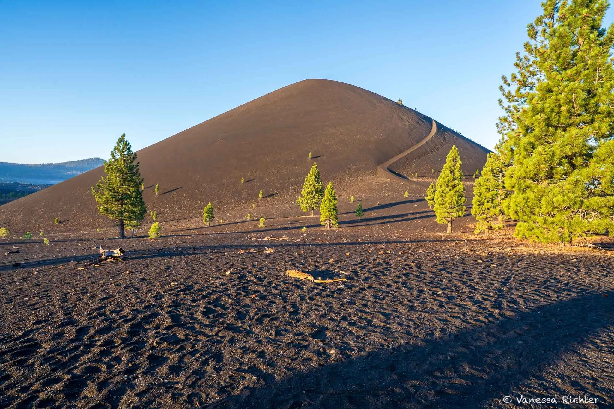
Morning light made the cone look chocolate-coated and lit the pines, the trail switchbacking up the side.
🌋 A Short, Loud Life
📅 Cinder Cone erupted in 1666. Over just a few months of activity, basaltic andesite poured from the cone's base in five distinct flows, including the colorful Painted Dunes and the blacker Fantastic Lava Beds. They dammed two creeks (creating Snag Lake) and partially filled the much older Butte Lake to the north.
🌲 The trees told the story. Jeffrey pines that survived the eruption recorded it in their rings: narrow growth and ash-borne chemistry both spike in 1666. Carbon dating of an aspen stump killed by the lava bracketed the same window.
🔒 Done erupting, at least here. Cinder cones are monogenetic volcanoes: they typically erupt once, then go quiet for good. Once the eruption ends, the conduit cools and seals shut. The Lassen Volcanic Center beneath the park is still active, but the next eruption will almost certainly come from a new vent.
As we got closer, the sun continued to rise with every step we took, and the chocolate-like coating gave way to the ashy grey of what it actually was. By the time we reached the foot of the cone, it was barely 6:30, but the sun was already relentless and the dark ground started absorbing in the heat. We spotted what looked, from a distance, like a path carved into loose sand running up the side. As we started up, I was relieved to find that the scoria underfoot — the dark and bubbly volcanic rock the cone is built from — wasn't fine like the eroded sand at the base, but coarser, more like gravel. Still strenuous, but at least it wasn't firing up our calves the way sand does.
The joy was short-lived. With every step, the loose rock gave way under our boots and took a little of our stamina with it. I was glad we'd dragged ourselves out before dawn. Hiking this in midday July sun, with no shade and the black ground throwing heat back at us, would have been brutal.
Slowly, the rim came closer. And then we were standing on it.
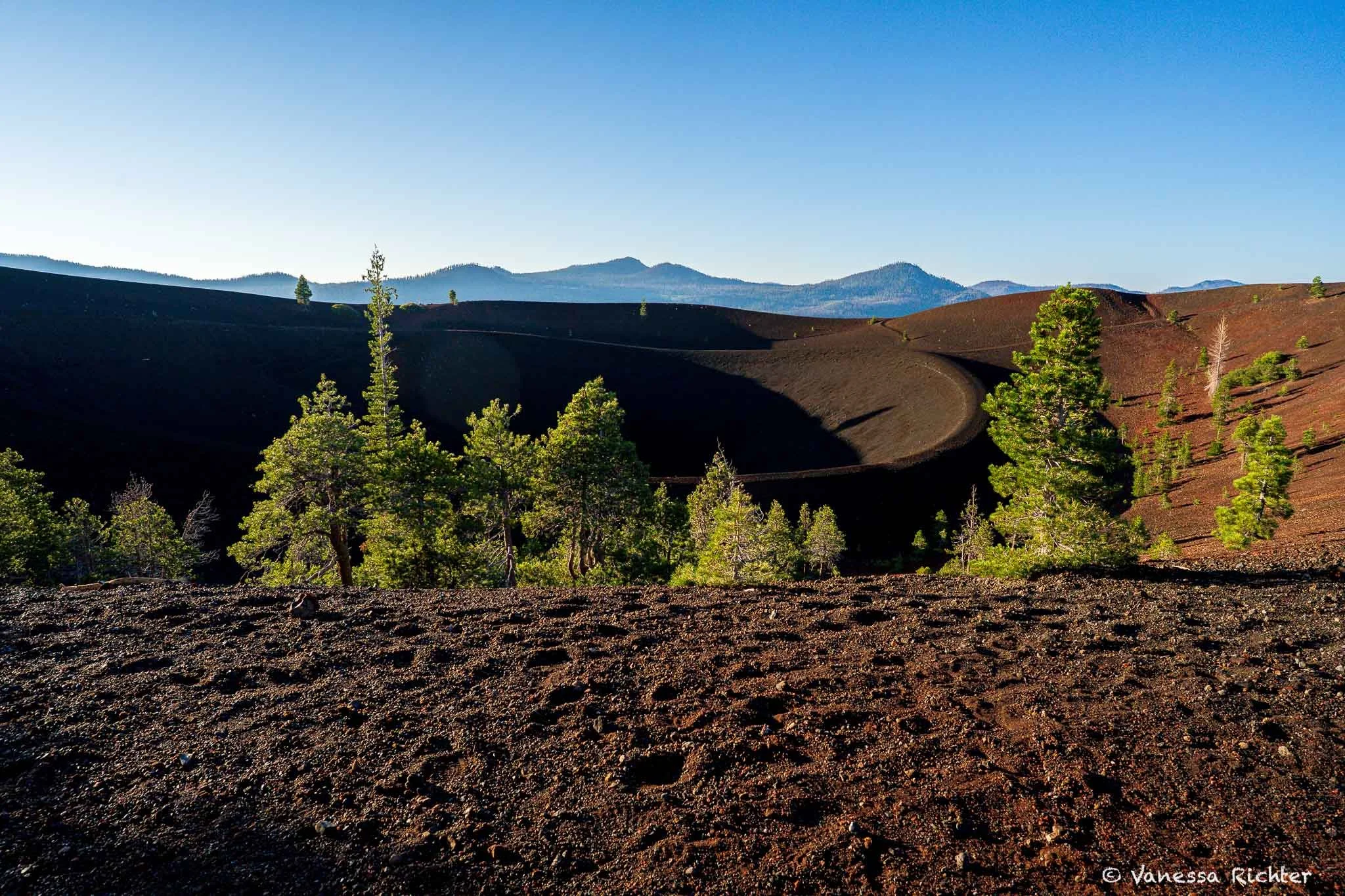
From up here, we could see the secret the volcano had been hiding from below. What looked like a round, closed cone from the bottom was in fact wide open. A wide outer rim circled an inner slope that dropped to a second rim, and beyond that, the dark mouth of the crater. Between the two rims, mostly pines had pushed through what could barely be called soil. They clustered where the roots could find a little water, stretching toward the sky. And then, on closer look, the sprinkles of bright yellow: small clusters of pale green leaves forming low mats, reddish stems pushing up with puffy yellow heads on top. Hard to believe the delicate roots of a flower could find enough hold in the scoria, let alone enough water. Every rain shower would run right through the loose gravel.
Looking down to the lower rim and the crater from above.
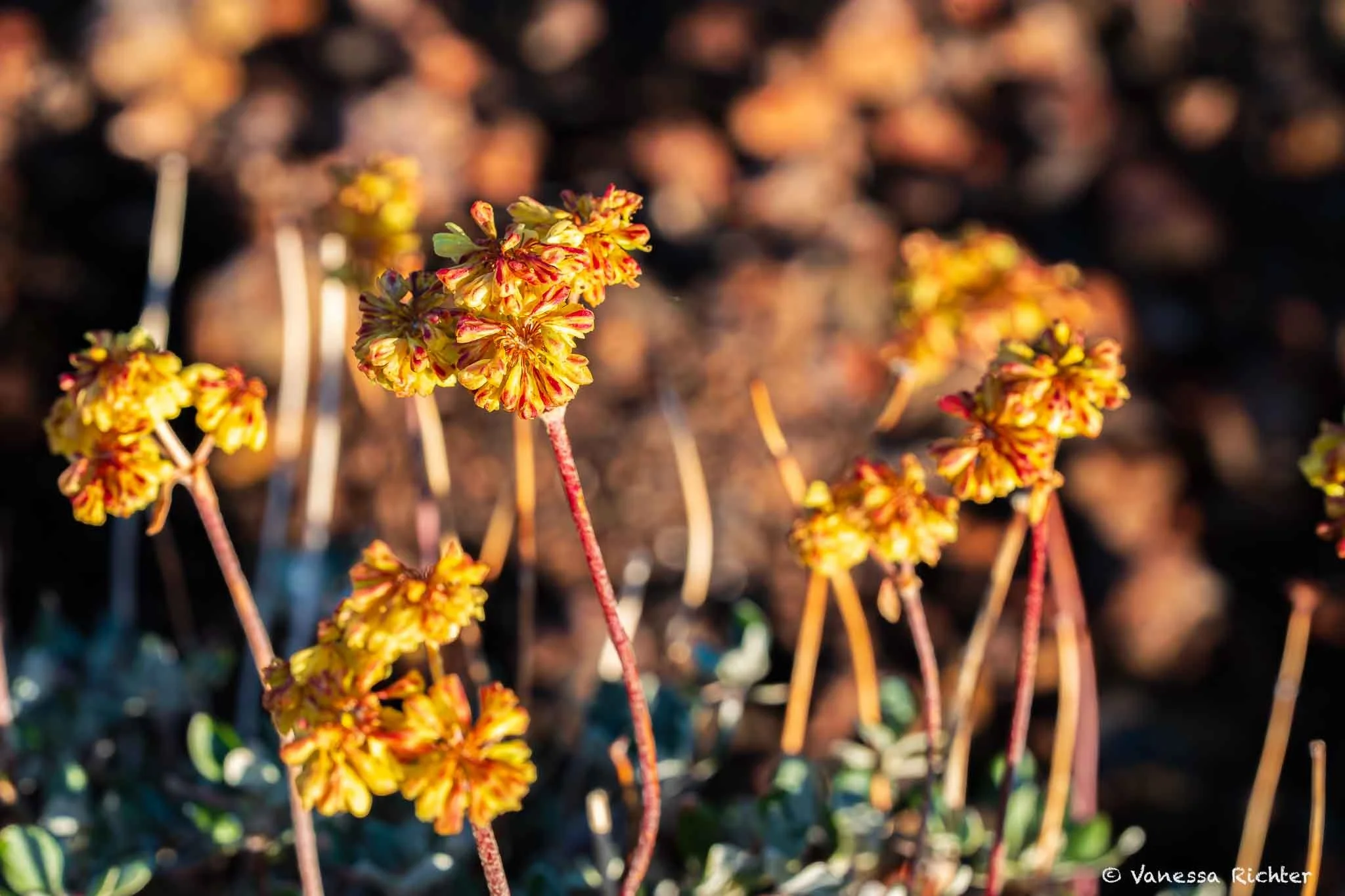
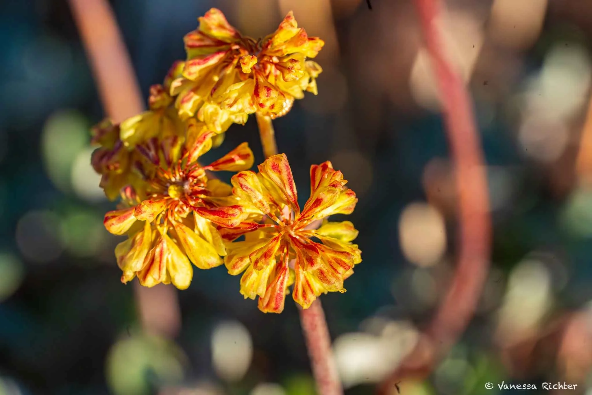
🌼 Wildflower Spotlight: Sulfur Buckwheat (Eriogonum umbellatum)
🌋 Built for the cinder fields. One of the few flowering plants tough enough to colonize raw volcanic soil. A low, mat-forming perennial that thrives where most plants give up.
🎨 Yellow that ages to rust. Bright sulfur-yellow sprays fade to orange, then deep rust as they age, so the same plant shows all three colors at once. Check out the pictures below (both taken on the cinder cone).
🦋 A pollinator powerhouse. Larval host for many butterflies (blue coppers, lupine blues, green hairstreaks, Mormon metalmarks) and a nectar stop for many more.
🌿 Not the only buckwheat here. Lassen is home to other buckwheats like marumleaf and naked buckwheat. They're a small slice of an enormous genus, with sulfur buckwheat alone splitting into a remarkable number of regional varieties.
Painted Dunes, Lassen Peak, and the Ghost of a Bigger Volcano
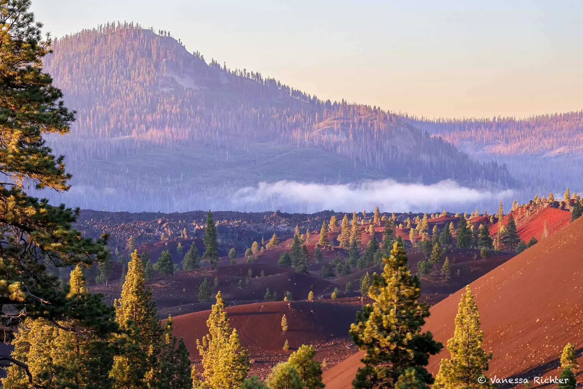
Having skipped breakfast, my stomach was starting to complain, but there was something I needed to see while the sun was still low. We followed the rim, and there it was: the view I'd seen in so many hard-to-believe photos. Waves of red and brown rolled away from the base of the cinder cone. Behind them stretched a giant field of ash-grey gravel, and beyond that, a ridge of dark forest with Snag Lake stretching in between. What lay before us, like a picture too perfect to be real, were the Painted Dunes and Fantastic Lava Beds.
And that wasn't even all of it.
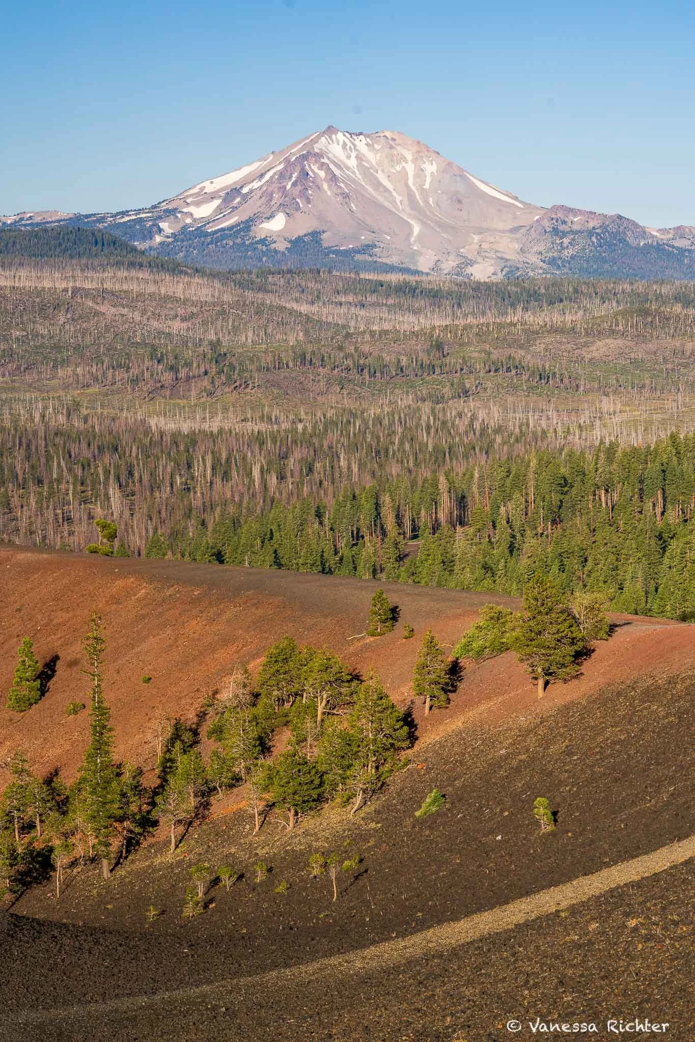
Lassen Peak, the larger, still-active cousin of Cinder Cone, towered above it all. Its peak shone pale gray under patches of snow, giving no hint of the hot magma chamber still alive in its core. It last erupted over 110 years ago, between 1914 and 1917, but the scars were still visible across the landscape. Somewhere beyond it lay Brokeoff Mountain, the eroded remnant of Mount Tehama: a stratovolcano that was once bigger than anything visible from where I stood, before its magma ran out and glaciers spent hundreds of thousands of years wearing it down to the ridge it is today. Lassen Peak itself grew from Tehama's flank long after the old volcano went quiet, a new volcano born from the ruins of an older one. Whether I could actually pick out Brokeoff's ridge from where I stood, I wasn't sure. Behind us, the broad green slope rising to the north was Prospect Peak, a shield volcano so wide and gentle it barely looks like a mountain at all. Between Cinder Cone, Lassen Peak, Brokeoff, and Prospect Peak, all four types of volcano that exist on Earth were within view from where I stood.
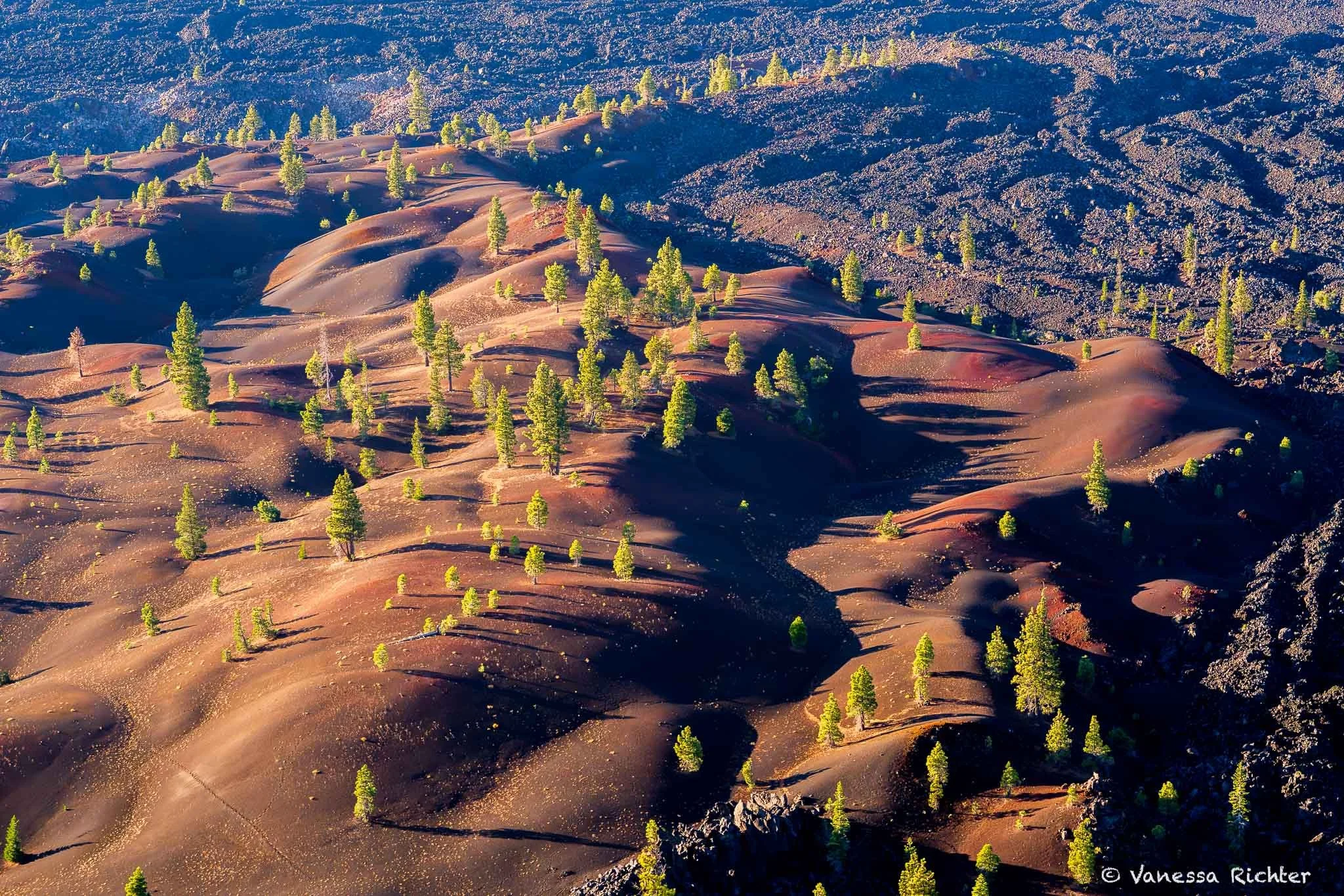
The Painted Dunes captured in early morning light, their colors warmed by both the low sun and the iron oxidized into the cinders themselves.
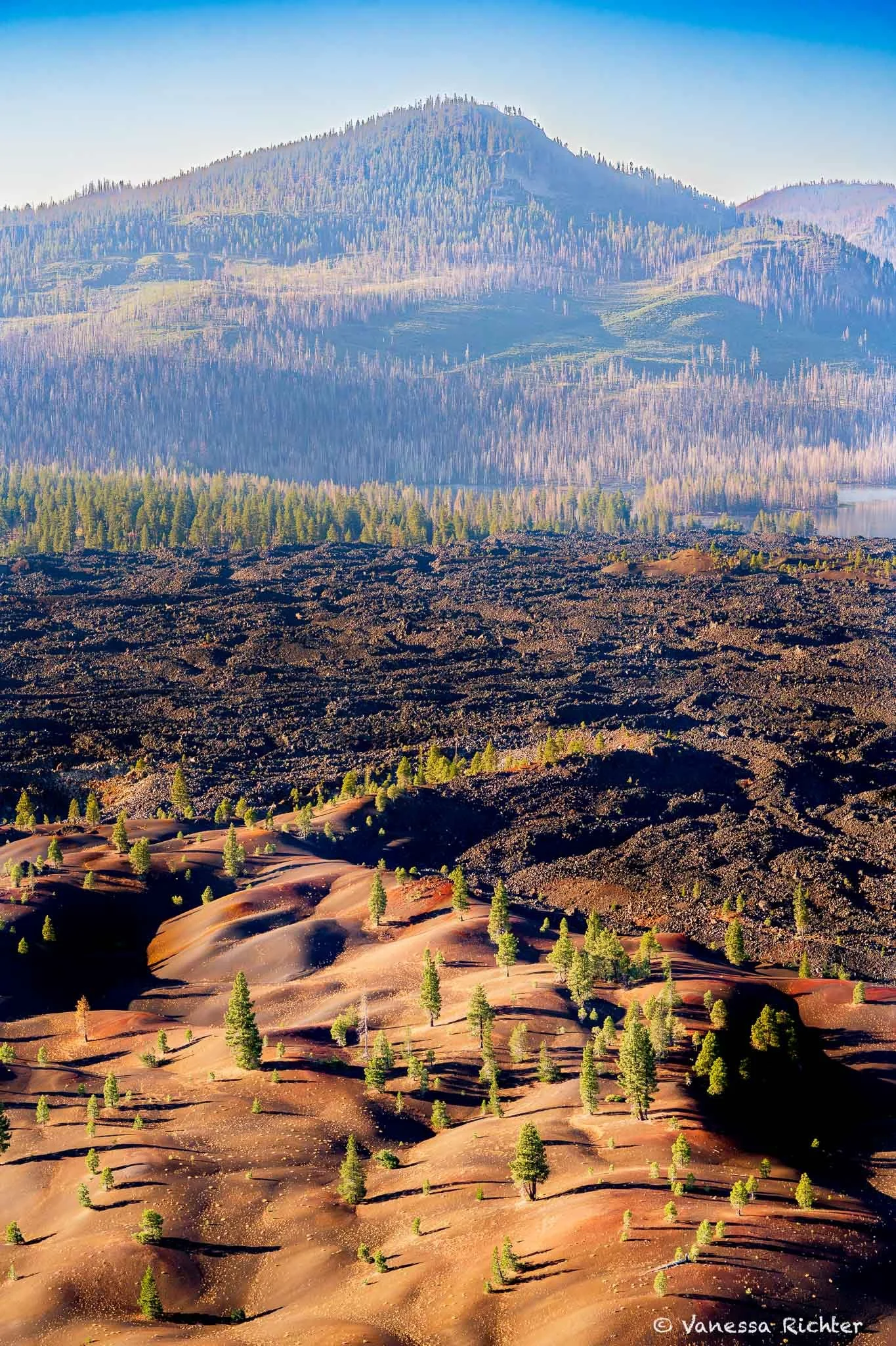
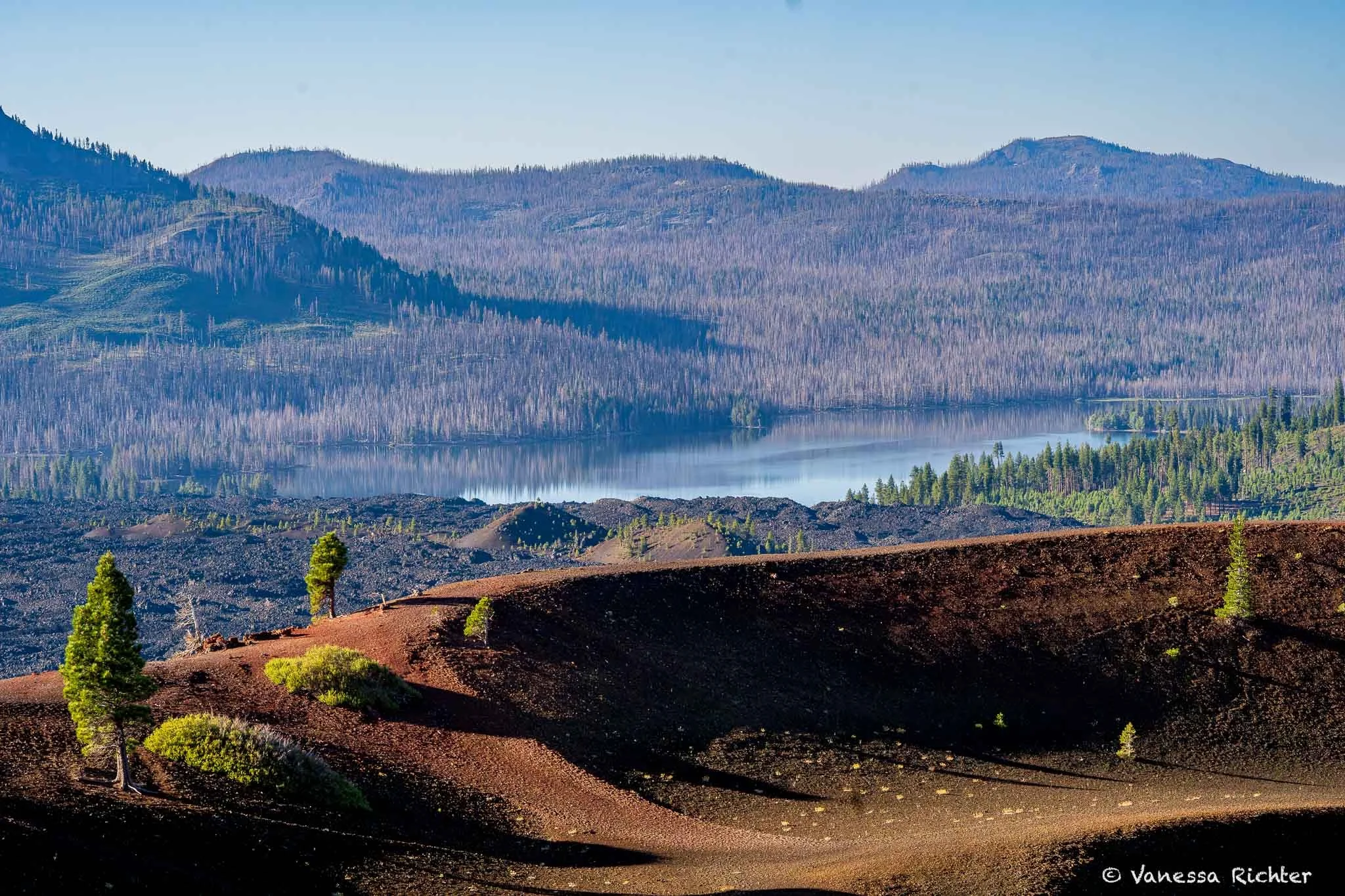
Snag Lake from the rim of Cinder Cone — shot at 90mm with my macro lens, which compresses the distance and makes the lake feel closer than it actually is from that vantage point.
💡 Know Your Volcanoes
🌋 The four primary volcano types aren't just about shapes; they're even more about what kind of lava made them and how that lava behaved when it reached the surface: Runny, sticky, gassy, or stuck. Each one builds a completely different kind of mountain, on a completely different timescale. The trickiest pair to tell apart is stratovolcano (also called composite) and plug dome, since both can be tall and steep. The difference is in how they form. A composite volcano is built layer by layer over hundreds of thousands of years of repeated eruptions, like a tiered cake. A plug dome forms from lava so thick it can barely flow, piling up around the vent and hardening in place. As it grows, the outer crust shatters and collapses, and trapped gases can explode outward, which is exactly what happened at Lassen Peak in 1915. Lassen Peak is a plug dome volcano that literally grew on the flank of the older composite volcano, Mount Tehama, whose eroded remains are now called Brokeoff Mountain.
| ▲ Cinder Cone | 🛡️ Shield | 🗻 Strato | 🥚 Plug Dome | |
|---|---|---|---|---|
| The lava | Gassy & frothy — shatters into pellets in mid-air | Runny like warm syrup — flows fast and far | Medium-thick — flows, but slowly | So thick it can barely flow — bulges up like toothpaste |
| What it's made of | Loose cinders piled around one vent | Many thin lava flows stacked on top of each other | Alternating layers of lava, ash, and rock | One solid mass of cooled lava — the dome is the lava |
| Time to build | Weeks to months — one short eruption, then done for good | 10,000s–100,000s of years — many gentle eruptions | 100,000s of years — many eruptions stacked up | Days to years per dome — but a dome field can keep producing new ones for millennia |
| Shape | Small, perfect, steep cone | Broad and low, like an overturned bowl | Massive, tall, symmetrical "iconic" volcano | Bulbous and lumpy — often grows on top of something else |
| In Lassen | Cinder Cone — erupted ~350 years ago | Prospect Peak, Mt. Harkness | Brokeoff Volcano (Mt. Tehama) — now eroded | Lassen Peak — erupted ~100 years ago; among Earth's largest plug domes |
Still smoldering. The boiling springs, mudpots, and steam vents scattered around the park are direct evidence that the volcanic center is still alive underneath. No one can say when or where the next eruption will be — only that there will be one.
From the upper rim, a trail led down to the lower rim and from there into the crater itself. While the darkness dropping into its center looked daunting from a distance, I could see that the crater was actually quite shallow. I could almost imagine the eruption winding down, the vent going quiet as the conduit below it cooled and sealed shut, stranding the crater above it.
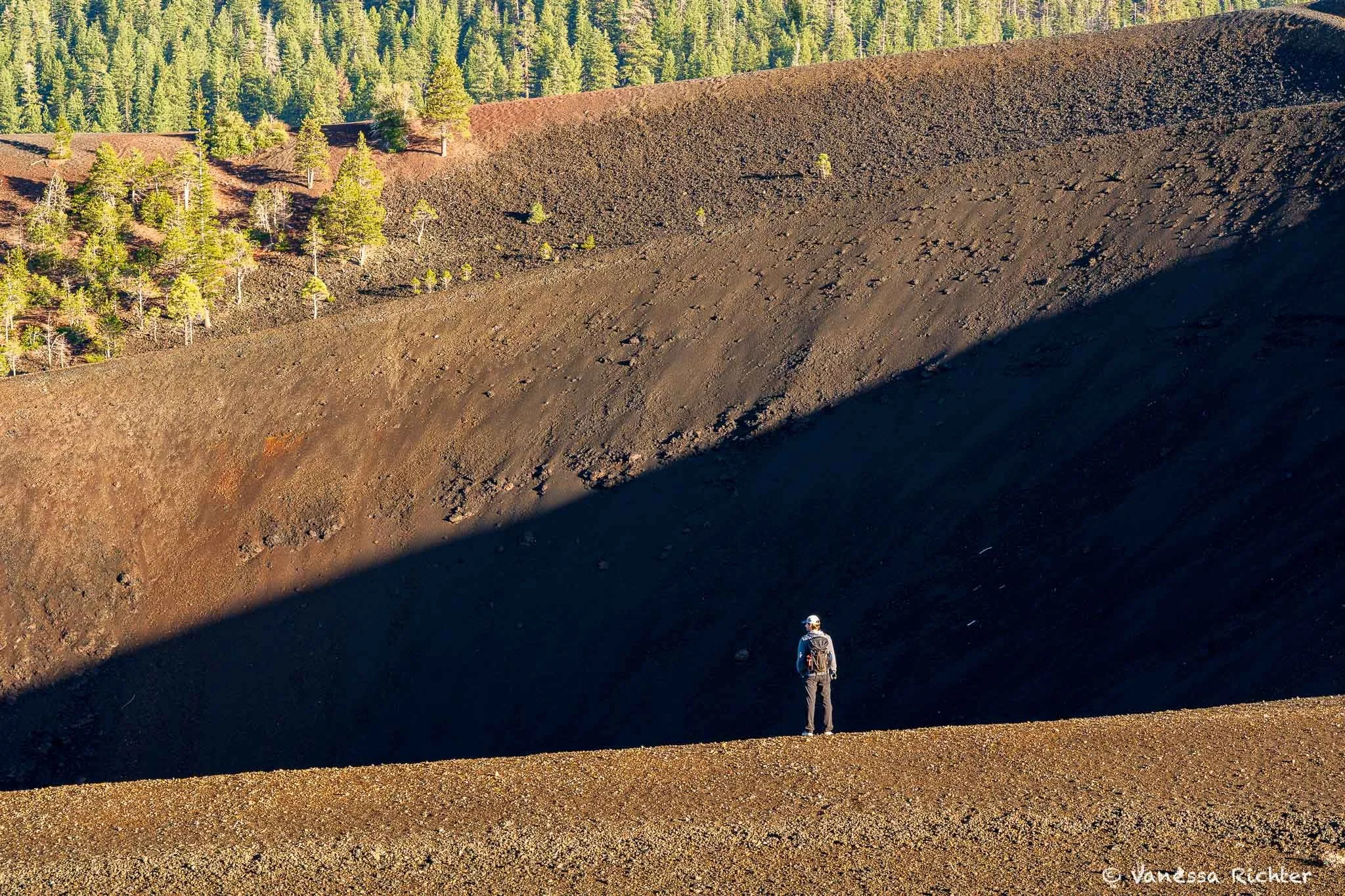
The cone's shadow stretches into the crater it created, with my husband on the rim hinting at the scale.
When we had explored everything we set out to see, we finally sat down on the ground that had started to warm up and enjoyed breakfast. If you go, set your alarm. Hike it early, before the heat builds and the crowds arrive, and give yourself time to stand on the rim without rushing. The chocolate-colored cone, the painted dunes, the sealed crater, the plants pushing through the inhospitable scoria, the ghost of a mountain bigger than anything you can see. It's a lot to take in. Worth every step of it.
🌿 The Naturalist's Kit
Turn a hike into a treasure hunt — the closer you can look, the more you know, the more there is to find.
Everything listed here is gear I actually use and recommend. Some of the links below are Amazon affiliate links, which means if you find a recommendation helpful and buy through my link, I receive a small commission at no extra cost to you. This is what makes free resources like this possible. If you liked my article and something here ends up in your pack, using my link is the best way to say thanks and keep this kind of content going.
👁️ Beyond the Naked Eye
One for what's far away, one for what's right under your nose.
🔭 Ultra-Compact Binoculars
My absolute essential on literally every hike, or pretty much anywhere I go. My go-to choice is super compact and lightweight — I don't even waste a thought about whether to bring them. I always do (if I don't forget them, because I am a headless zombie sometimes).
🔎 Magnifying Loupe
Super small and easy to forget you're carrying it. Volcanic rocks like scoria are full of frozen gas bubbles and mineral detail that are almost invisible to the naked eye. Small flowers are the same: the sulfur buckwheat on Cinder Cone's rim has structure you simply can't see without magnification.
📖 Know What You're Looking At
The tools that turn a hike into a discovery.
The best plant and wildlife ID tool out there. Photograph anything you can't identify, and the app suggests what it is based on your location. The community then confirms or corrects it. It is also a great way to contribute to citizen science, so the data can be used for research later. Free.
Open iNaturalist →Made by the Cornell Lab of Ornithology, Merlin identifies birds by listening to their song in real time. Get your phone out on the trail and watch it name the birds singing around you. Make sure to download the bird pack for your region before you head out. Free.
Open Merlin →My go-to for finding and planning hikes. The free version gives you trail maps, reviews, difficulty ratings, and live GPS tracking while you have signal. AllTrails+ (paid) adds offline maps, wrong-turn alerts, and more detailed map layers. Check the recent reviews before you go for current conditions.
Open AllTrails →I haven't found a field guide specifically covering the Cascade Range and Lassen that I'd recommend yet — let me know in the comments if you have one. In the meantime, I still bring John Muir Laws' Sierra Nevada guide. The species overlap with the Cascades is large enough for it to be useful, and no other guide comes close to the details, format, illustrations and organization of the book. I wish there were a field guide like this for more places.
Get The Laws Field Guide →📸 Cameras & Lenses
On this hike I switched between two setups:
Full Frame + Macro & Wide-Angle
My main setup for this hike — most of the photos in this article were taken with it. The Sony A7C is one of the most compact full-frame bodies out there, with rich colors and excellent low-light performance. Despite the name, the 90mm macro is incredibly versatile: I used it for flower close-ups, but also for the Painted Dunes and other scenery from a distance, where its sharpness and compression really shine. The 20mm wide-angle prime comes in when I need to capture the full width of a scene from up close — like standing on Cinder Cone's rim and taking in the whole crater. It's an investment, but very reasonable for what you get.
Crop Sensor + Telephoto
For wildlife and landscape details in the distance that require a closer shot. The 100–400mm zoom gives you the reach that matters when you spot a bird across a meadow or want to pull in a distant detail, without the weight or price of a full-frame telephoto. Crop sensor cameras are also a great starting point if you're new to photography — much cheaper than full frame, and still much better quality than a phone.
In case you're interested in my full hiking gear setup, I've linked it here.
Know Before You Go
Access
- The Cinder Cone trailhead sits at Butte Lake, in the park's remote northeast corner. There's no road through the park to reach it — drive Highway 44 to Forest Road 32N21 (Butte Lake Road), then 6 miles south to the parking area.
- Butte Lake Road is unpaved but well graded — fine for standard 2WD when snow-free. It typically opens in May and closes in November — check current road conditions before heading out.
- Allow ~1.5 hours from the Kohm Yah-mah-nee (southwest) Visitor Center.
- Arrive early. The trailhead lot by the boat launch is small; overflow parking, restrooms, and seasonal potable water are at the Butte Lake Campground loop you pass on the way in.
- No dogs on the trail (service animals only).
- For current trail and road status, plus an interpretive guide keyed to numbered posts along the trail, check the NPS Cinder Cone page. For recent hiker reviews, photos, and conditions, AllTrails is the place to check.
Best Time to Visit
- Summer (June–August): Long days, the most reliable weather, and wildflowers in bloom, but the cinder fields radiate heat and there's almost no shade above the forest. Start around sunrise; early light also makes the Painted Dunes glow.
- Fall (September–October): Cooler temps, fewer bugs, and the most comfortable hiking conditions.
- November–May: Butte Lake Road is closed by snow. The first heavy snowfall typically triggers the closure in November; the road usually reopens in late May, though it can stretch into June.
Leave No Trace
Lassen's volcanic landscape is more fragile than it looks. A couple of things especially worth keeping in mind here — for the broader principles, Leave No Trace is a great resource.
- The best view of the Painted Dunes and Fantastic Lava Beds is from the rim of Cinder Cone — which is also lucky, because walking out onto them does lasting damage. Footprints in the loose cinders scar the landscape for decades, the lichens slowly building soil there can't recover from being trampled, and the lava hides sharp edges and deep fissures.
- Pack out everything — including organic scraps like apple cores and orange peels. At this elevation and dryness, they take far longer to disappear than you'd guess.
I hope you enjoyed this article — by a real human for real humans. If you liked this hiking story and guide, you can help me continue creating free resources like it.
Buy me a coffeeRead On


Follow the Adventure
Latest on the Blog

Looking For Something?