A Nature Lover’s Guide to Redwood National & State Parks: Best Hikes, Forest Life, and Scenic Drives
This post contains affiliate links. If you book through them, I may earn a small commission at no extra cost to you — thank you for supporting this blog.
Have you ever wondered what Earth looked like millions of years ago, when dinosaurs wandered freely across an untamed landscape? Do you picture vast, open stretches interwoven with dense forests, filled with lush vegetation and colossal trees, resilient enough to satisfy the appetites of these gigantic creatures?
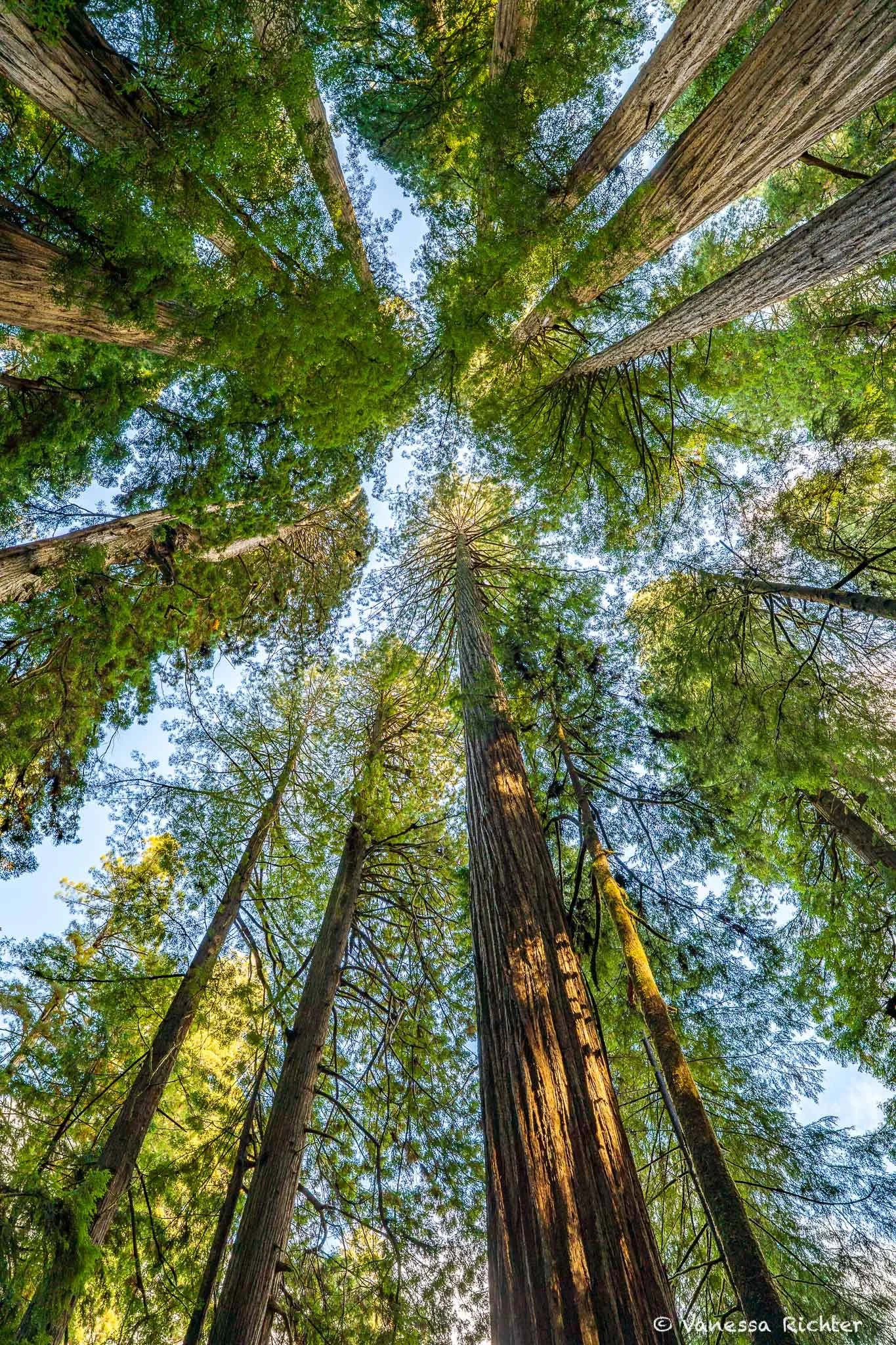
Redwood National and State Parks (RNSP) in the far north of California invite your imagination to glimpse into an era when dense forests filled with ferns and giants ruled the Earth. To me, a hike through a redwood forest feels like stepping back into an ancient era, one so distant that its scale is almost beyond human understanding.
While even these dense, remote forests haven’t been spared severe losses, RNSP is a place where pristine old-growth redwoods alongside secondary growth preserve crucial habitat for plants and wildlife—and, of course, support us too in so many ways.
Due to RNSP’s complicated history, it actually consists of a number of parks that are managed together: Del Norte Coast Redwoods State Park, Jedediah Smith Redwoods State Park, Prairie Creek Redwoods State Park, and Redwood National Park. In this guide, we’ll explore some of the best hikes, scenic drives, as well as plant and wildlife highlights throughout this park network (and a bit beyond).
🌲 What You’ll Get From This Guide
📍 Everything you need to plan your visit to Redwood National and State Parks, from must-see spots to practical tips that help you use your time wisely.
🌿 Plant and wildlife highlights, including iconic redwoods, lush ferns, coastal ecosystems, and animals you might encounter along the way.
🥾 The best hikes and scenic drives, whether you have just a few hours or several days to explore.
🍂 Seasonal insights and essential tips, so you know what to expect throughout the year and can make the most of your time in the park.
Contents
Overview Map
At A Glance: The History of Redwood National & State Parks
Ancient Forests Threatened By Logging
Redwoods once covered roughly 2 million acres along the Pacific Coast of California. By the late 19th and early 20th centuries, intensive logging driven by the Gold Rush and railroad expansion had reduced old-growth forests by nearly 96%.
These towering giants—some over 2,000 years old and more than 350 feet tall—faced near extinction without large-scale conservation efforts.
The Birth of the State Parks
California’s redwood protection efforts began decades before the creation of a national park. In the early 1900s, public concern over logging led to the formation of the Save the Redwoods League in 1918.
Through a combination of private donations, land purchases, and state support, key groves were set aside as protected areas. This led to the establishment of Jedediah Smith, Prairie Creek, and Del Norte Coast Redwoods State Parks between the 1920s and 1930s—preserving some of the most pristine remaining old-growth forests.
These state parks became critical refuges at a time when federal protection for redwoods did not yet exist.
The Creation of a National Park & Shared Management
By the mid-20th century, conservationists recognized that remaining redwood forests outside the state parks were still vulnerable. After years of advocacy and debate, Redwood National Park was established in 1968 to provide broader federal protection.
In 1978, a cooperative agreement between the National Park Service and California State Parks unified federal and state lands under a single management system, now known as Redwood National and State Parks.
Together, these parks safeguard approximately 139,000 acres, preserving nearly 45% of the world’s remaining old-growth coast redwoods.
Plant and Wildlife Highlights
Redwoods & Redwood Sorrel
A Forest Partnership
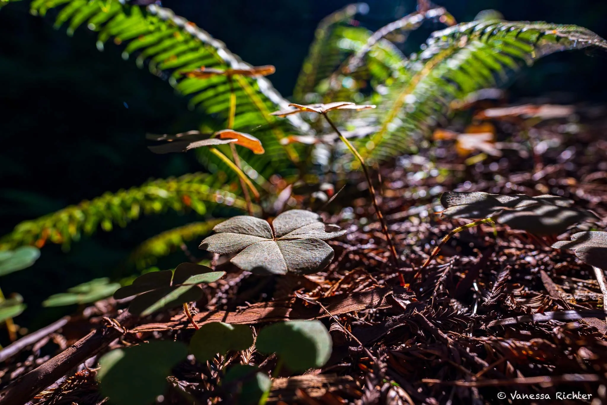
Redwoods are among the tallest and oldest trees on Earth, with some living over 2,000 years and soaring more than 350 feet into the sky. Their massive trunks, often exceeding 20 feet in diameter, and dense canopies create the cool, shaded microclimates that define the redwood forest. Beneath these giants, carpets of redwood sorrel (Oxalis oregana), alongside ferns and other plants, spread across the forest floor, displaying their small, heart-shaped leaves with a purple underside that respond to sunlight and shade.
Redwoods have shaped Pacific Coast forests for tens of millions of years, surviving glacial cycles, dramatic climate shifts, and even massive wildfires. Redwood sorrel evolved alongside them, perfectly adapted to the low-light, high-moisture conditions beneath these towering trees.
💡 Did You Know?
🪚 Historically, redwood forests covered approximately 2 million acres in California. Today, about 96% of old-growth redwood forests have been lost to logging. Redwood National and State Parks now protect around 45% of the world’s remaining old-growth coast redwoods.
💧 During California’s dry summers, fog provides nearly 40% of a redwood’s water intake, sustaining redwoods with moisture when they need it most.
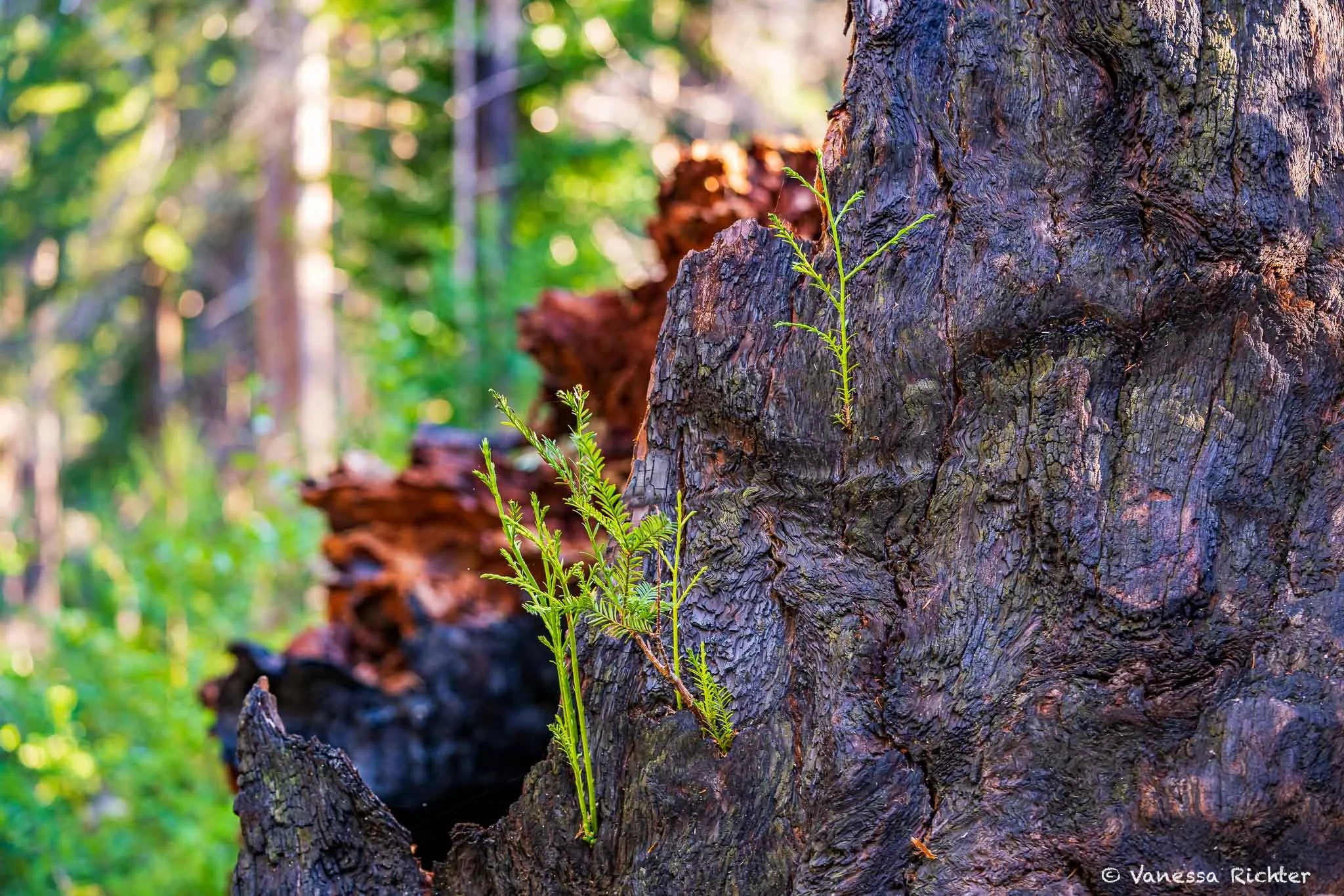
🔥 Fire plays an important role in redwood forests. While Redwood cones open naturally as they dry, fire helps clear leaf litter, competing plants, and exposes soil for seeds and sprouts to grow. Redwoods also resprout from burls and roots, helping the forest recover after low- to moderate-intensity fires.
🌡️ Climate change makes fires hotter, more frequent, and more intense, which can harm even mature redwoods.
🌿 Where Redwoods & Redwood Sorrel Thrive
🌲 Redwoods:
Grow in valleys, riverbanks, and protected coastal slopes with deep, moist soils
Require consistent moisture, fog, and cool temperatures
🍀 Redwood sorrel:
Carpet the forest floor beneath redwood canopies
Thrive along trail edges, creek banks, and moss-covered slopes where shade and moisture are abundant
🌱 Ecological Role
Redwoods and redwood sorrel play complementary roles in the forest ecosystem:
🌲 Redwoods:
Stabilize soils and prevent erosion.
Regulate local climate and store massive amounts of carbon.
Provide habitat for countless species, from insects to birds and mammals.
🍀 Redwood sorrel:
Retains soil moisture, keeping the forest floor damp for other plants.
Provides food for insects, small mammals, and herbivores.
Forms soft understory mats that shelter small ferns, shrub seedlings, and other low-growing plants
Together, they maintain the layered structure of the forest, that provides many ecological niches supporting a rich web of life.
🔎 How to Recognize
🌲 Redwoods:
Massive, straight trunks with reddish-brown, fibrous bark.
Needles are long, flat, and slightly curved, growing in flattened sprays along branches.
Can form groves with interconnected root systems, supporting younger trees.
🍀 Redwood Sorrel:
Small, heart-shaped leaves in clusters of three, purple underside.
Leaves fold up in shade or darkness and open in sunlight.
Tiny white or pinkish flowers appear in spring, often almost hidden beneath the leaves.
🔎 Observation tip: Notice the contrast of towering trees above and the soft, green carpet of sorrel below. The way limited light filters through the dense forest canopy onto the forest floor can feel especially magical.
Ferns
How fern many species can you spot?
Ancient Survivors: When Dinosaurs Disappeared, Ferns Prevailed
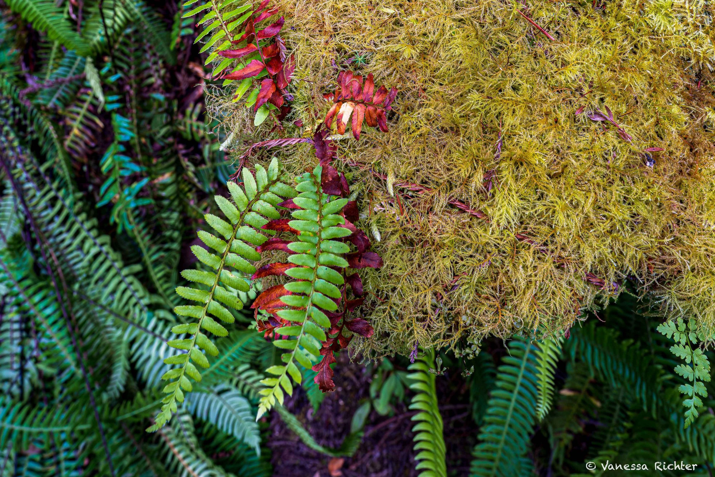
Ferns are some of the oldest plants on Earth, with a lineage stretching back over 350–400 million years. Long before redwoods towered above, ferns were shaping forest floors, regulating moisture, and creating lush, green habitats.
Millions of years ago, herbivorous dinosaurs likely grazed on ferns and other low-lying plants. While many ancient fern species are now extinct, ferns as a group survived multiple mass extinctions and continued to evolve. Over the past 70 million years, new species emerged, adapting to changing climates, ecosystems, and the rise of flowering plants. This long evolutionary journey has made ferns remarkably resilient, allowing them to thrive worldwide.
Today, ferns are the second-most diverse group of vascular plants, surpassed only by flowering plants, with around 10,500 living species.
🌿 Where Ferns Thrive
Ferns love moist, shaded environments, and the redwood forest provides perfect conditions.
Look for them:
Along creek banks
On north-facing slopes
Clinging to mossy logs or damp canyon walls
Fog drip and consistent rainfall keep the forest floor damp year-round, creating dense fern communities.
💡 Even small differences in sunlight, slope, or soil moisture can give rise to entirely different fern species in each pocket of the forest.
🌱 Ecological Role
Ferns shape their environment in subtle, yet vital ways:
Stabilize soil and reduce erosion.
Retain moisture for other plants.
Provide shelter for insects, amphibians, and small mammals.
Enrich the soil as fronds decompose, feeding a web of life from tiny fungi to towering redwoods.
🔎 How to Recognize
Ferns come in all shapes and sizes, and different species can look so similar yet be so different when you look closely. Here’s what to look for:
Frond shape: Ferns can have very different overall shapes. Some fronds arch in sweeping curves, draping over logs or forest soil, while others grow upright, like miniature green spears reaching for the light. Some species have single, unbranched fronds, while others divide repeatedly into smaller leaflets, creating a feathery, lace-like appearance.
Leaflets (pinnae): Look closely at the individual leaflets. They may grow opposite each other along the central stem or staggered, and the edges may be smooth, serrated, or deeply lobed. The number of times a frond branches and the arrangement of the leaflets can help you tell species apart.
Spores (sori): Check the undersides of the fronds for clusters of spores, called sori. These may appear as tiny dots, lines, or patches, and their pattern, shape, and placement differ between species.
Growth location: On soil, mossy logs, or damp rocks — location can help identify types.
New growth: Fronds unfurl as coiled fiddleheads, sometimes hairy or scaly.
Keep An Eye Out For Their Differences: While fern species may look similar at first sight, you might notice that there are actually so many different species out in a single forest.
Roosevelt Elk
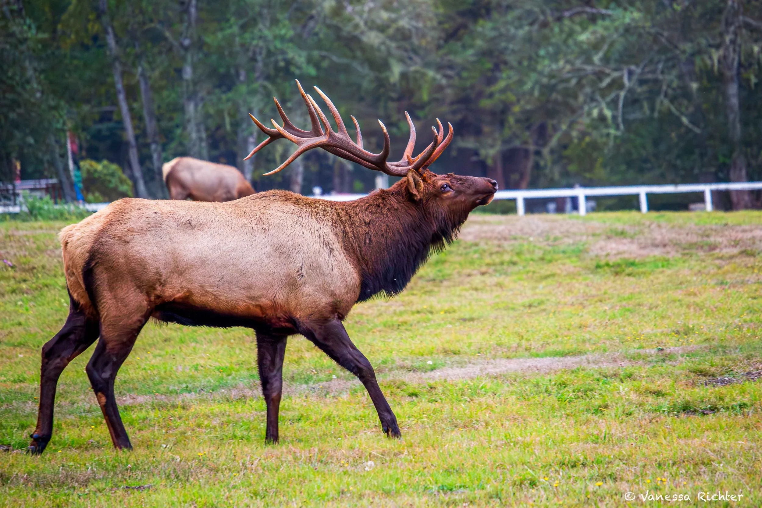
Once almost Lost: The decline And Rebound Of California’s Largest Elk
Once, millions of elk roamed North America. Three subspecies of elk occur in California, with the Roosevelt elk (Cervus elaphus roosevelti) being the largest. Back then, they ranged from southern British Columbia south to Sonoma County in California. For thousands of years, indigenous people managed and used elk sustainably for food, clothing, and tools. In California alone, it’s estimated that pre-colonization herds, including Tule, Roosevelt, and Rocky Mountain elk, numbered over 500,000 individuals. Then, in the late 1800s, European settlers arrived, bringing large-scale hunting and agriculture. By 1907, elk numbers had plummeted to less than 100,000.
Thankfully, the rapid decline sparked early conservation efforts, including the creation of Prairie Creek Redwoods State Park, aimed at protecting one of California’s last wild herds of Roosevelt elk, alongside towering old-growth forests. Today, these populations are slowly rebounding. With conserved habitats, active management, and translocations, elk are expanding their range again. While they’ll never reach historic numbers due to permanent habitat loss, their recovery since 1970, when they occupied less than 10% of their former range, has been remarkable. California now hosts roughly 5,700 Roosevelt elk, 5,700 tule elk, and 1,500 Rocky Mountain elk.
Within Redwood National and State Parks, seven herds make their home, though these groups often shift and mingle. Key areas include Crescent Beach, Gold Bluffs Beach, Prairie Creek Redwoods State Park, Elk Meadow, Lower Redwood Creek, Orick Valley, and the Bald Hills. The Bald Hills herd is the largest, with around 250 animals, while the other herds range from 10 to 50 elk.
Maintaining these positive trends won’t be easy, as human development and land conversion continue to threaten their habitat.
Best Places To See Roosevelt Elk
⭐ In Redwood National and State Parks, Roosevelt elk can be seen throughout the park, from Freshwater Lagoon in the south to the Klamath River in the north. They use a variety of habitats, including forests, prairies, Redwood Creek gravel bars, and even beaches.
Top viewing areas include:
Crescent Beach area
Gold Bluffs Beach
Prairie Creek Redwoods State Park
Elk Meadow
Lower Redwood Creek
Park lands in the Orick Valley
Bald Hills
Best Time To See Roosevelt Elk
⭐ August - October: This is the rut season when bulls bugle, spar, and gather harems.
However, roosevelt elk can be seen year-round.
Time of Day: Best time to spot them is ⭐ during dawn and dusk when they are most active.
⚠️ Keep a Safe Distance
Roosevelt elk are wild animals and are best admired from afar. To keep both you and the elk safe, maintain a distance of at least 25–50 yards. Males can be especially unpredictable during the fall rut (late August through October), so giving them plenty of space helps reduce stress and allows them to behave naturally. The same is true for females during calving season (late May through June), when they may also become aggressive toward humans.
Banana Slugs
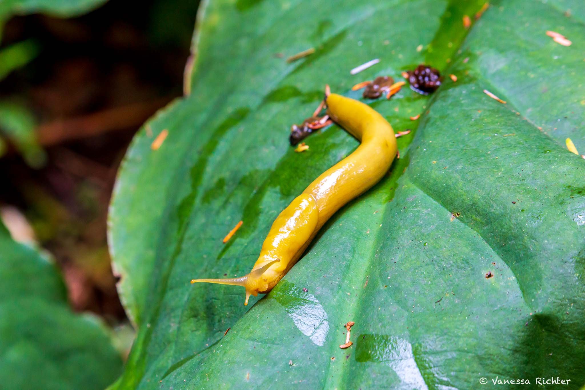
Nutrient Recycler, Seed Disperser, and a Source of Food: How Banana Slugs Play a Vital Role in the Ecosystem
With their slow movement, slime-gleaming bodies, and, of course, yellow skin, banana slugs are not difficult to spot, even though they’re small. It’s truly not hard to see what gave the banana slug its name. However, not all individuals look as deep and uniformly yellow as the one in my photo; some have dark spots, while others appear more greenish or even brown. Their appearance is unique, just as it is for humans.
While they’re small compared to many other animals, banana slugs are actually quite large for their own group. They are among the largest terrestrial mollusks, a group that also includes snails, and can grow to more than 7 inches (20 cm) long. Like most other slugs, banana slugs are hermaphrodites, meaning each individual has both male and female reproductive organs. While they can technically self fertilize, this is rare, and they typically seek out a partner to ensure genetic diversity. Fertilized eggs are laid under logs or among fallen leaves.
As detritivores, banana slugs play an important role by breaking down dead organic matter, such as fallen leaves and fungi, and recycling nutrients into soils that support towering redwoods and the rich understory beneath them. As they digest material, they produce nutrient-dense waste, also known as slug poop, which helps fertilize the soil and support plant growth.
But that’s not all. They also feed on fruits and berries and can contribute to seed dispersal when seeds pass through their digestive system and are deposited elsewhere in the forest. In this way, banana slugs support the ecosystem by recycling nutrients and spreading seeds. They are also an important food source for other species, including raccoons, garter snakes, and salamanders that prey on them.
Best Places To See Banana Slugs
⭐ Fern-filled forest floors, damp trails, and shaded areas across Redwood National and State Parks (and other places along the coast that provice similar conditions).
Best Time To See Banana Slugs
⭐ Fall through spring, especially during wet, rainy periods, but overall they can be seen year-round.
Time of Day: ⭐ Early morning or after rain, when moisture is highest and slugs are most active.
⚠️ Keep a Respectful Distance
Observe them without touching: Banana slugs are delicate, and handling can harm them or remove their protective mucus.
Favorite Hikes & Scenic Drives
🥾 Essential Day Hiking Gear I Rely On
After years of trial and error, I’ve finally found hiking shoes that work across almost all terrains, a backpack that actually keeps my back cool, and a hydration setup that stays lightweight without sacrificing comfort. Plus, all the small things that make a hike noticeably more enjoyable. I’ve put everything together—from core essentials to the camera gear I rely on out on the trail.
→ See What I Actually Pack for Every Hike🚗 Howland Hill Road
🌲 Location: Jedediah Smith Redwoods State Park
🚗 Road Length: 10 mi (16 km)
⏱ Drive Time: Allow about 1 hour
🛣 Road Type: Narrow (one lane, two ways), unpaved forest road
⚠️ Vehicle Restrictions: No RVs, trailers, or extremely wide vehicles
📜 Good to Know: Former stagecoach road with tight turns and close-up redwood views
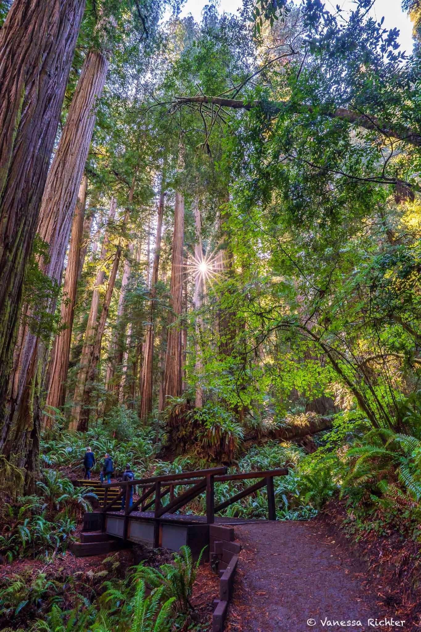
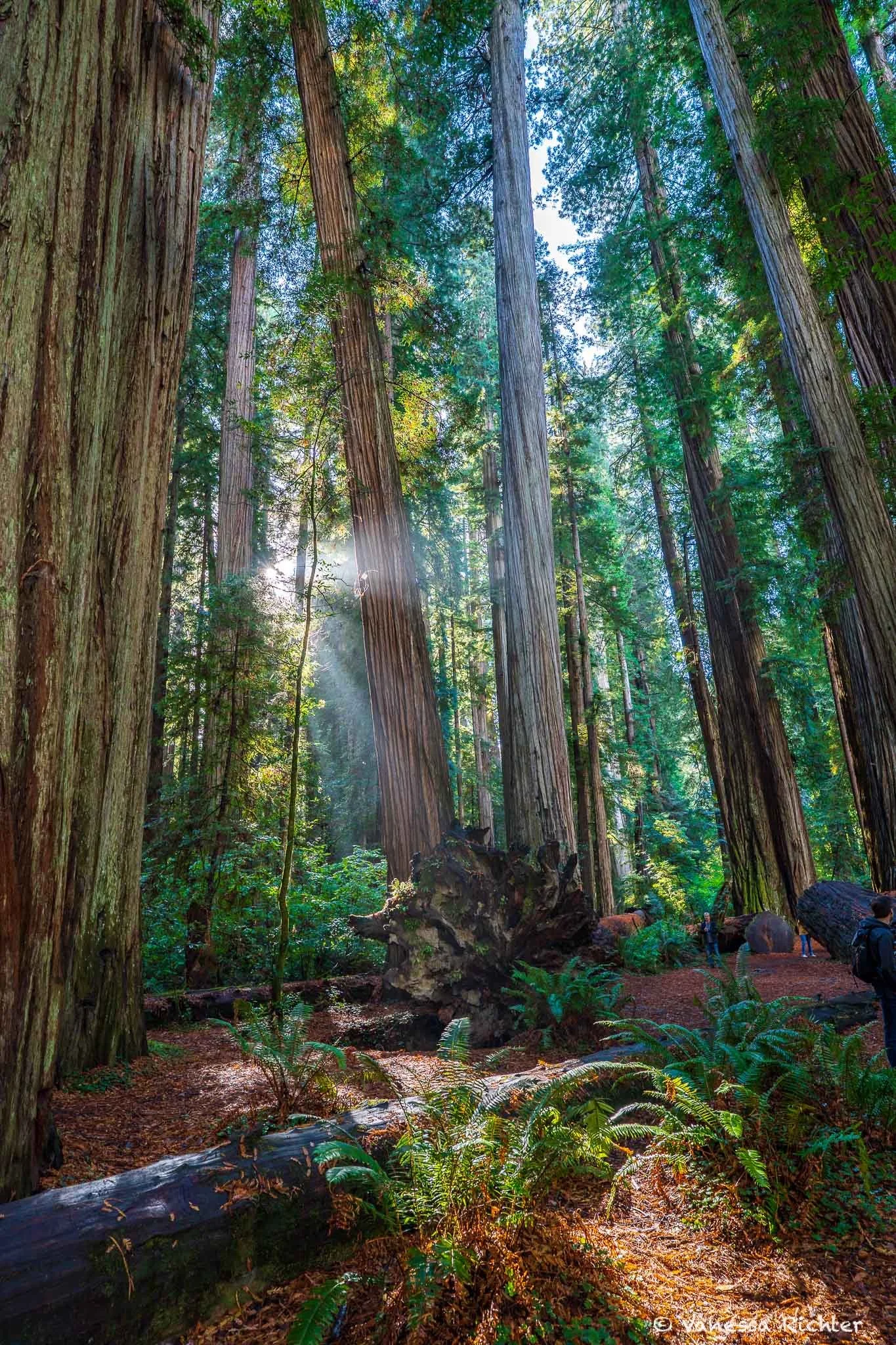
Imagine yourself driving on a narrow, winding dirt road. To your left and right, giants rise, dressed in rough, chocolate-brown robes. You step out of your car, trying to see their faces. But they don’t have faces, only strong arms and legs, and atop their heads sit crowns so high you have to stretch your neck to see them. The crowns aren’t golden; they shimmer in a deep, dark green that fades into the endless sky.
Howland Hill Road is one of the most essential scenic drives to see massive coastal redwoods up close, meandering through an ancient forest. It is a single lane with occasional pull-outs, so take it slow, because this drive is the destination itself. To fully experience the forest, step off the road and walk among the trees to explore the ecosystem more closely.
Thankfully, Howland Hill Road is not just a scenic drive; it also provides access to several trails along the way. Read on to learn more about the best hikes you can explore along this incredible route.
🥾 Grove of Titans
📍 Distance: ~1.7 mi (2.7 km)
⛰ Elevation Gain: ~147 ft (45 m)
🔙 Route Type: Out & Back
⭐ Short Trail Among Ancient Giants
The Grove of Titans Trail starts off Howland Hill Road and is one of the best trails for seeing some of the most massive and ancient redwoods in existence.
The grove is quiet and awe-inspiring, especially magical in misty conditions or during the soft light of early morning. Watch out for banana slugs and snakes when the ground and vegetation are wet!
🥾 Boy Scout Tree Trail
📍 Distance: ~5 mi (8 km) round-trip
⛰ Elevation Gain: ~500 ft (152 m)
🔙 Route Type: Out & Back
The Boy Scout Tree Trail is a longer option along Howland Hill Road, starting near the Grove of Titans. It takes you deeper into old-growth redwood forest, with highlights including the iconic Boy Scout Tree and the picturesque Fern Falls.
⚠️ Seasonal Note: Trail conditions can vary—heavy rains, restoration work, or fire management may cause temporary closures. Check the park website for up-to-date alerts before your hike.
🥾 Stout Memorial Grove
📍 Distance: ~0.6 mi (1.0 km)
⛰ Elevation Gain: ~32 ft (10 m)
🔁 Route Type: Loop
Quick Loop With Giant, Old-Growth Redwoods
The Stout Memorial Grove Trail carries a similar charm to the Grove of Titans and Boy Scout Tree Trail and is the shortest among these top trails along Howland Hill Road for experiencing towering old-growth redwoods up close. This gentle loop winds through a dense redwood forest along the Smith River.
🥾 Fern Canyon
📍 Distance: ~1.1 mi (1.8 km)
⛰ Elevation Gain: ~127 ft (39 m)
🔁 Route Type: Loop
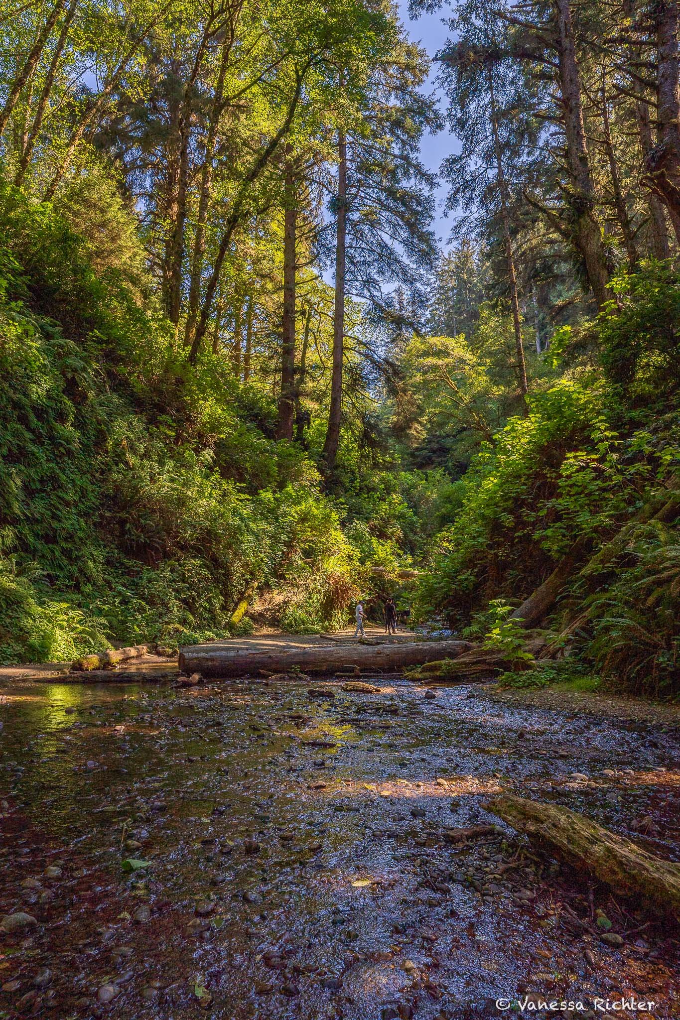
⭐ Step Into a Dinosaur World of Dripping Ferns
This is one of the most popular hikes within Redwood National and State Parks, and for good reason: Water drips from above through countless ferns, mingling with moss to create a soothing, almost otherworldly sight. It’s no wonder that part of the second Jurassic Park movie was filmed here.
⚠️ Access varies. For direct access to the short Fern Canyon Loop, a parking permit is required from May 15 to September 15, which you can reserve here. The last stretch to the parking lot is unpaved and can be rough, with puddles after rain or in the fall and winter. No permit is needed to access the James Irvine Trail (see more on this trail below) to hike down to Fern Canyon.
💧 The water level in Fern Canyon may be higher from fall through spring, especially in winter. Wooden footbridges are typically installed from June to September. Outside these months, be prepared to either remove your shoes or get them wet when traversing the entire trail.
At A Glance: How To Visit Fern Canyon
Access & Parking
For the short access to Fern Canyon Loop, a parking permit is required from May 15 – Sept 15. You can reserve a permit here.
No permit is needed to access Fern Canyon via the James Irvine Trail, which allows you to hike down from the trailhead in Prairie Creek Redwoods State Park.
Trail Options
The Fern Canyon Loop is a short 1.1-mile (1.8 km) walk along the canyon floor, with walls covered in ferns and moss.
You can also combine Fern Canyon with the James Irvine Trail for a longer hike (see below for more info).
Conditions & Tips
- Water levels may be higher from fall through spring. Wooden footbridges are typically installed June – September, but expect to remove shoes or get them wet when walking the canyon.
- Pets are not allowed on the trail.
- Start early to avoid crowds—Fern Canyon can get busy on summer weekends.
- Best visiting hours: morning light for photos and a quiet experience.
Useful Links
🥾 James Irvine Trail
📍 Distance: ~10.3 mi (16.6 km)
⛰ Elevation Gain: ~1,400 ft (427 m)
🔙 Route Type: Out & Back

⭐ Between Redwoods, Banana Slugs & The Beach
The James Irvine Trail winds through towering redwoods and ancient ferns, with occasional sunbeams piercing the leafy canopy to create a magical glow. Lichens hang from branches, hinting at the frequent coastal fog that provides much-needed moisture during California’s dry summers. Midway on this out-and-back hike, the trail opens to the ocean at Gold Bluffs Beach and the magical Fern Canyon.
This trail truly has it all: massive redwoods, abundant wildlife, the ocean, serenity, and all the magic of the forest. That’s why it’s one of my favorite trails in Redwood National and State Parks.
🚗 Extra Tip: Avenue of the Giants (Outside RNSP)
The Avenue of the Giants is a scenic 31-mile drive through Humboldt Redwoods State Park, winding among some of the tallest and oldest redwoods just south of Redwood National and State Parks.
If you’re traveling to or from the southern stretches of the California coast, this iconic route lies directly along your way. Running parallel to Highway 101, the Avenue of the Giants has several access points on and off the highway, giving you plenty of flexibility in how much time you choose to spend exploring the scenic road.
⭐ Make the Most of Your Drive
🏛️ Visitor Center
A worthwhile stop along the Avenue of the Giants, the visitor center features a well-curated educational exhibit and a thoughtfully selected gift shop with books and redwood- and park-related items.
🌲 Founders Grove
Located just a short drive from the visitor center and close to Highway 101, Founders Grove is an easy loop trail that winds through some of the tallest redwoods along the Avenue of the Giants. The trail is about 0.6 miles long, mostly flat, and perfect for a relaxed stroll beneath the giant trees.
Know Before You Go
Park Structure & Access
Redwood National and State Parks is a joint system made up of several state parks and one national park unit, spread along the Northern California coast and inland river valleys. Expect some driving between areas.
Most trailheads are accessible year-round, though some areas are reached via narrow or unpaved roads, which can be temporarily closed after storms. Be sure to check for required permits before heading out (for example, for visiting Fern Canyon).
Best Time to Visit & Weather
The parks are beautiful year-round. Temperatures along the Northern California coast are generally mild in all seasons.
October–April is the rainy season, with the heaviest rainfall from December through February. Trails may be muddy, creeks swollen, and some roads temporarily closed. Fog is common and drifts inland from the ocean. However, don't let this deter you — the weather can often be quite nice, and winter means fewer visitors and therefore a quieter experience.
April–September is drier and more stable, though coastal fog frequently rolls in, especially in the mornings. Inland areas are warmer and sunnier.
Layered clothing is recommended year-round.
Campgrounds
There are several excellent campgrounds across Redwood National and State Parks, including:
- Jedediah Smith Campground: Nestled among old-growth redwoods beside the Smith River; popular for swimming and hiking.
- Mill Creek Campground: The largest campground in Del Norte Coast Redwoods State Park, shaded by maples, alders, and smaller redwoods.
- Elk Prairie Campground: In Prairie Creek Redwoods State Park, surrounded by forest and meadows; good for wildlife viewing, including Roosevelt elk.
- Gold Bluffs Beach Campground: Near the beach and coastal trails; rugged setting with shoreline views.
Booking ahead is recommended, especially during peak season from May through September, as campgrounds fill quickly. View campground details here.
Visitor Centers
Redwood National and State Parks has five visitor centers providing educational exhibits, maps, and park information. These include:
- Hiouchi Visitor Center – Located in Del Norte Coast Redwoods State Park, near Crescent City.
- Jedediah Smith Visitor Center – Near the Smith River, offering trail info and exhibits about old-growth redwoods.
- Crescent City Information Center – General visitor information and park resources.
- Prairie Creek Visitor Center – Exhibits on local wildlife, forest ecology, and park history.
- Thomas H. Kuchel Visitor Center – Near Orick; features interactive exhibits and a small gift shop.
Leave No Trace
The principles of Leave No Trace are essential for preserving these forests. A few key reminders:
🗑️ Pack It In, Pack It Out
Pack out all trash, including biodegradable food scraps, which can take years to decompose in this ecosystem.
🌿 Minimize Human Impact
Avoid unnecessary noise, observe wildlife from a distance, and do not collect plants, shells, or other natural items. Removing natural objects is illegal in national parks.
🐾 Pets
Pets are not allowed on most trails. Dogs on leash are permitted in certain developed areas, campgrounds, parking areas, and select beaches. Always check posted signs or park regulations.
Following these principles helps keep the forests healthy.
Six years ago, 97% of California's oldest state park was engulfed in flames. Now, it is one of the most hopeful places I've set foot in. I went to see the recovery for myself, and dug into the new research explaining it. Click on picture to read the article.
Follow the Adventure
Latest on the Blog

Looking For Something Else?
I’m the writer and photographer behind Venture Beyond the Picture.
You're in the right place if you're looking for nature-focused guides, real tales from the trails, and photography that celebrates wild landscapes. I'm especially drawn to the quieter, equally fascinating details in nature that are easy to miss, and to digging into the ecological story of a place. You'll find a range of easy-to-scan travel guides, deep dives, stories from my favorite hiking trails, and the occasional science-y exploration of the latest research on ecological topics.