Nature-Focused Guide to Point Reyes National Seashore
This post contains affiliate links. If you book through them, I may earn a small commission at no extra cost to you — thank you for supporting this blog.
Where sky and ocean seem to dissolve into infinity, elephant seals lounge on the soft beaches below a rugged shoreline. Above them, tule elk and coyotes roam the cliffs, as wind and fog sweep across scrub and grasslands stretching as far as the eye can see. This sense of wildness is what makes Point Reyes National Seashore one of my favorite places to explore.
Beneath its dramatic landscapes runs the San Andreas Fault, slicing straight through the park. Tomales Bay, also called Earthquake Bay, marks the hidden boundary between the Pacific Plate and the North American Plate, shaping the land still to this day.
Point Reyes is not just a place where tectonic plates cross paths: The park shelters a rich mix of resident and migratory birds, and during certain seasons, whales can be seen migrating along the coast. It’s also a place of remarkable recovery: species that once vanished locally, hunted close to extinction, including tule elk and elephant seals, have returned thanks to long-term conservation efforts.
🐋 What You’ll Get From This Guide
📍 Everything you need to plan your visit to Point Reyes, from first-time planning to practical tips that help you make the most of your time.
🌊 What makes Point Reyes so special, including its wild coastline, diverse ecosystems, and ever-changing landscapes shaped by fog, wind, and ocean.
🥾 The best hikes and wildlife highlights, from coastal trails and forests to places where you might spot tule elk, elephant seals, or migrating whales.
🍂 What to expect in different seasons, including weather patterns, wildflowers, wildlife activity, and trail conditions.
🏕️ Where to stay and essential tips, helping you plan everything from campgrounds to nearby lodging and get the most out of your visit.
Contents
Tide Pools
Overview Map
Check out the map below to see where hikes, tide pools, campgrounds or wildlife viewing areas are!
Wildlife Viewing Highlights
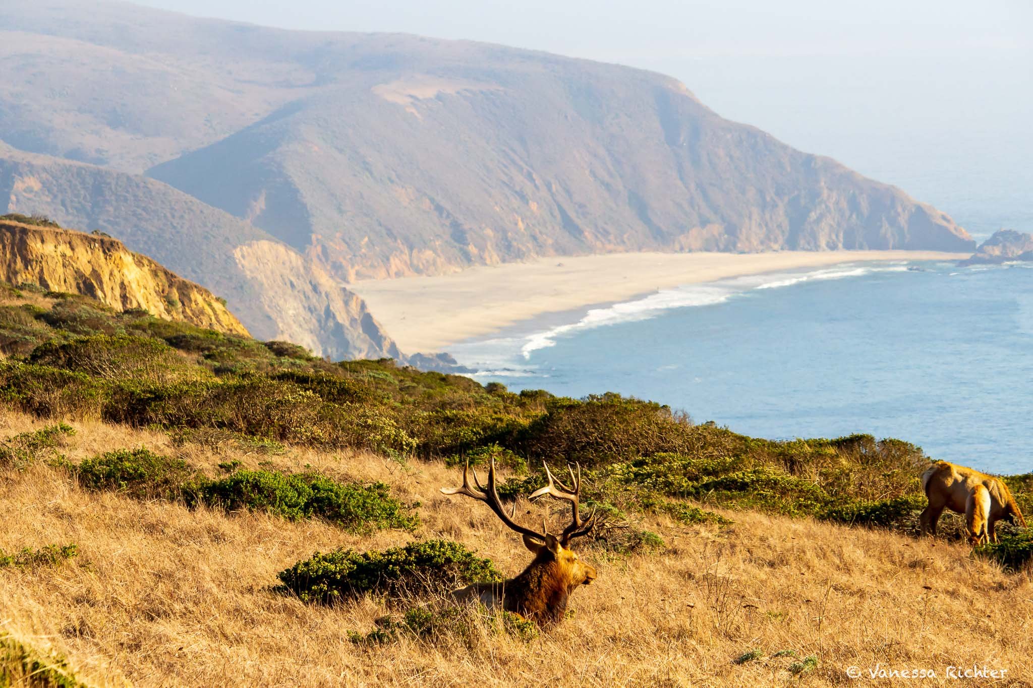
Tule elk

Tule elk were locally extinct at Point Reyes — thanks to conservation efforts, they now roam there again.
From Near Extinction to Recovery: How Tule Elk Returned To Point Reyes
Once widespread across coastal California and the Central Valley, tule elk numbered up to 500,000 before the Gold Rush of 1849 triggered rapid decline through hunting and habitat loss.
By the 1870s they were thought extinct, until rancher Henry Miller discovered a herd of just 30 animals and, thankfully, protected them.
Officially protected in 1971, tule elk returned to Point Reyes in 1978 with a small reintroduction at Tomales Point. Today, about 5,700 tule elk live in California across 22 herds—all descended from that last surviving group.
Best Places To See Tule Elk
⭐ Tule Elk Reserve: The best spot to see them is where they were first relocated—at Tomales Point and the so-called Tule Elk Reserve. More on the hike to the reserve below.
Scattered Across Point Reyes: You can also see them elsewhere. Just keep an eye out over the grasslands and ridges, and you may spot them.
Best Time To See Tule Elk
⭐ August - October: This is the rut season when bulls bugle, spar, and gather harems.
However, tule elk can be seen year-round.
Time of Day: Best time to spot them is during dawn and dusk when they are most active.
⚠️ Keep a Safe Distance
Tule elk are wild animals and are best admired from afar. To keep both you and the elk safe, maintain a distance of at least 25-50 yards. During the fall rut, males can be especially unpredictable, so giving elk plenty of space helps reduce stress and allows them to behave naturally in their habitat.
Northern Elephant Seals
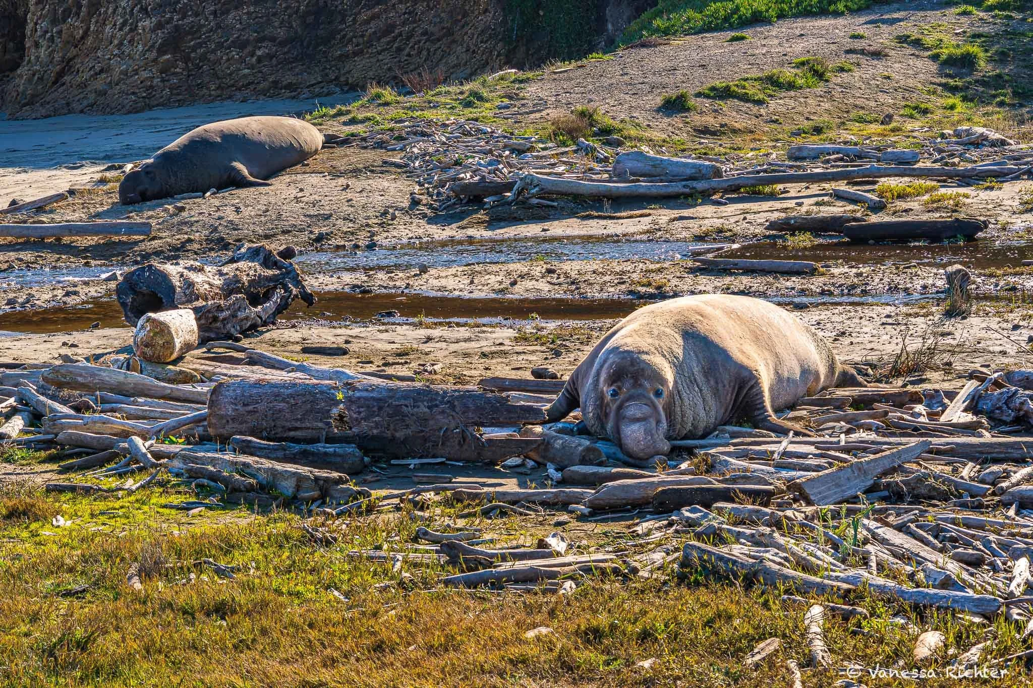
This male elephant seal may look cute, but when two males fight, things can get really messy.
Almost Hunted to Extinction, Northern Elephant Seals Thrive again at Point Reyes
Similar to the conservation story of tule elk, northern elephant seals were believed to be extinct in the 1800s after being hunted extensively for their blubber. Fortunately, a small population in Mexico survived, and in the early 1900s, the population began to grow steadily.
At Point Reyes, northern elephant seals returned to sandy pocket beaches on the south side of the Point Reyes Headlands in the early 1970s. About ten years later, in 1981, the first breeding pair was found near Chimney Rock. Since 2019, they have started breeding again at Drakes Beach. While the population at Point Reyes is steadily growing, the largest colonies of northern elephant seals are found on the Channel Islands.
Being the largest of the “true” seals in the Northern Hemisphere, they are quite a sight. Adult males, which can weigh up to 5,000 pounds (!), have large, inflatable noses that they use during the breeding season to vocally threaten other males. Females are much smaller, weighing about a third as much as males.
Best Places To See Elephant Seals
Elephant Seal Overlook (near Chimney Rock)
This is one of the best places in the park to observe a large colony of elephant seals from above. From the Chimney Rock Trailhead parking area, follow the signs to the Elephant Seal Overlook, a short walk of about 0.3 miles. The overlook sits above Drakes Bay and offers great views of seals hauled out on the beach below. Bring binoculars. On weekends and holidays between December and March, wildlife docents may be present with spotting scopes.⭐ Drakes Beach
Because you’re on the same level as the elephant seals at this spot, this is the best place to see them up close (remember to keep at least 300 feet of distance — it’s the law). To protect the seals and visitors, much of beach area is closed to foot traffic from about December 15 through mid-June, and sections may close entirely when large numbers of seals are present. You can view the seals from the parking lot and nearby sidewalk. When volunteers or staff are present (typically daily from about 10 am to 4 pm in peak season), they can answer your questions. Check current conditions before your visit, especially if planning to go during January–March.
Best Time To See Elephant Seals
Northern elephant seals spend 6 to 8 months at sea, diving almost continuously during their migrations. Some individuals have been recorded traveling over 13,000 miles roundtrip. Compared to other seals, they can hold their breath for an astonishingly long time, allowing them to dive for up to two hours and reach depths of 300–800 meters.
The rest of the year, elephant seals come ashore for three reasons: breeding, molting (shedding their old skin), and resting (juveniles only). Depending on their sex and where they are in their life cycle, they haul out at different times of year. Here’s when you can see each group at Point Reyes:
⭐ December – March
This is the breeding season and best time to see them in large numbers in action. Adult males and females gather on the beaches to breed, and pups are born during this time. Note: If you’re aiming for the height of the action, plan your visit for late January or early February.April – August: Molting Season
This is when elephant seals shed their skin. Adult females and juveniles typically come ashore first, between April and May/June. Once they leave, adult males take over the beaches between July and August.Note: Late summer is the quietest time of the year.
September – November: Juveniles
During fall, juveniles haul out on beaches to rest and recover before heading back out to sea.
⚠️ Keep a Safe Distance
Northern elephant seals are protected by the Marine Mammal Protection Act (like all marine mammals!). Always stay at least 100 yards (300 feet) away — getting closer can disturb these giants and is illegal.
Birding
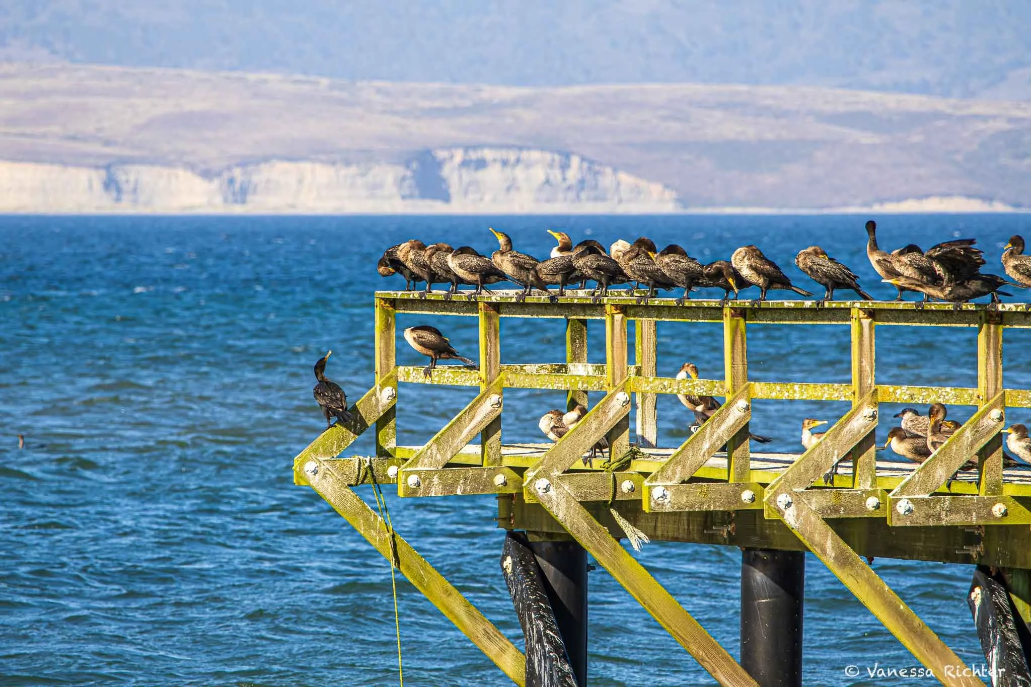
Cormorants resting on a weathered pier near Chimney Rock. Fun to observe them diving!
A Birding Hotspot like No Other In the U.S.: Nearly 490 Species at Point Reyes
With nearly 490 bird species recorded, Point Reyes National Seashore boasts the greatest bird diversity of any U.S. national park—and more than half of all bird species found in North America. In fact, the total number of species observed here exceeds the entire species list of forty U.S. states.
Several factors make Point Reyes a magnet for birds. Its location along the Pacific Flyway, diverse and largely unspoiled habitats, and the peninsula’s unique shape—jutting nearly ten miles into the Pacific—create ideal conditions for migrants, wintering birds, and even rare “vagrants” that have wandered off course. This remarkable diversity is why Point Reyes consistently ranks among the highest bird counts in the nation during the annual Christmas Bird Count.
Conservation Spotlight
While all birds at Point Reyes are protected, two threatened species receive special attention and ongoing conservation efforts:
Western Snowy Plover – A small shorebird that nests on sandy beaches and is especially vulnerable to disturbance.
Northern Spotted Owl – A forest-dependent species closely monitored in the park’s wooded areas.
Best Places For Birdwatching
Great birding throughout the park! There’s not one best spot, but many that are great for seeing different kinds of birds:
Abbotts Lagoon
Excellent for winter ducks and raptors. White-tailed kites are commonly seen in fall and winter. This area is also a sensitive nesting site for western snowy plovers—please be especially careful during spring and early summer.
Bear Valley
High songbird diversity, including warblers, woodpeckers, hummingbirds, and owls.
Bolinas Lagoon
A major stopover for waterfowl and shorebirds, Bolinas Lagoon attracts egrets, cormorants, pelicans, kingfishers, and more. The lagoon lies directly along Highway 1, so even if you’re not planning to spend much time here, keep your eyes open if you drive through the area.
Giacomini Wetlands
Since restoration began in 2008, shorebirds and waterfowl have returned in large numbers. Watch for American wigeon, bufflehead, green-winged teal, American coot, Wilson’s snipe, California black rail, sandpipers, and egrets. Raptors such as osprey, northern harriers, white-tailed kites, and occasional bald eagles may be seen overhead.
Limantour
Limantour is a place where marshes, ponds, dunes, and beach meet, which allows a variety of bird species to thrive here. Expect wading birds in the marshes, waterfowl on ponds, shorebirds along the beach, brown pelicans offshore, and birds of prey soaring above the dunes.
Cliff Areas
Any place close to the ocean that has rocks is a top spot for seabirds, including pelicans, cormorants, murres, oystercatchers, and occasional peregrine falcons.
Best Time to See Birds
Birding at Point Reyes is rewarding year-round, but different seasons bring different highlights:
⭐ Fall and Spring Migration
Most dynamic time that offers the greatest variety, including songbirds, shorebirds, seabirds, and the occasional rare vagrant.Winter (December – February)
Excellent for waterfowl, raptors, and owls.Spring – Early Summer
Breeding season for many species. It’s important to be mindful of seasonal nesting closures, particularly along beaches.Summer
Quieter overall, yet far from empty: coastal areas continue to host seabirds, while grasslands and wetlands can still be surprisingly productive.
⚠️ Keep a Safe Distance
All birds at Point Reyes are protected wildlife. Avoid approaching nesting birds, stay out of closed areas, and follow posted signs; especially on beaches during spring and early summer when snowy plovers are nesting. Disturbing wildlife can cause birds to abandon nests and, therefore, be harmful to their survival.
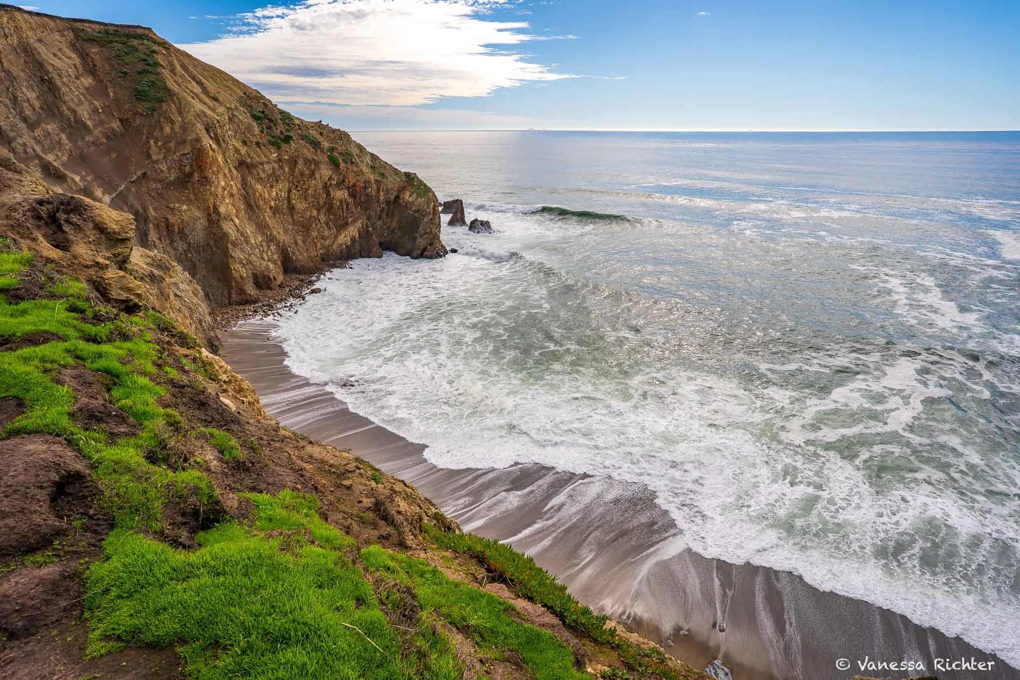
Whale Watching (From the Shore)

The tail of a humpback whale emerging from the ocean.
Following Ancient Migration Routes | One of the Best On-Shore Whale-Watching Locations On The West Coast
Since the Point Reyes Peninsula juts nearly 10 miles (16 kilometers) into the Pacific Ocean, it is among the best land-based whale-watching locations along the California coast.
The most commonly seen whale off the coast of Point Reyes is the California gray whale. Driven by seasonal changes in food availability and the need for warmer waters where females can give birth, gray whales undertake the longest migration of any mammal on Earth! Each year, they travel more than 10,000 miles (16,000 kilometers) roundtrip—swimming from their feeding grounds in Alaska to the breeding lagoons of Baja California, Mexico, and back again. On both legs of this journey, they pass directly by Point Reyes.
After the gray whale, the humpback whale is the next most sighted whale at Point Reyes. Humpback whales migrate north from their winter waters off of Mexico and Central America to the Gulf of the Farallones off the shore of Point Reyes where they feed during the summer and fall.
If you’re extremely lucky, you might even get to see blue, fin, or minke whales. Common dolphins, bottlenose dolphins, and harbor porpoises can also frequently be seen, with orcas irregularly making an appearance.
Best Places To See Whales
On clear days, whales may be visible from many stretches of coastline within the park, but the most reliable viewing opportunities are found at the very tip of the peninsula, known as the Point Reyes Headlands. The ⭐ Point Reyes Lighthouse, ⭐ Chimney Rock, and Tomales Point perch above deep offshore waters, placing you directly along major migration routes.
Best Time To See Whales
⭐ December–January & March–October
December–January
Southbound gray whale migrationFebruary
Transition period with fewer gray whales, but occasional sightings still possibleMarch–May
Northbound gray whale return
Late April–early May: best chance to see mothers and calves, which often travel closer to shoreJune–October
Peak season for humpback whales feeding offshore
Possible sightings of blue, fin, and minke whales (rare), plus dolphins and harbor porpoises, orcas irregularly
Marine Life in the Intertidal Zones: Tide Pools
Duxbury Reef
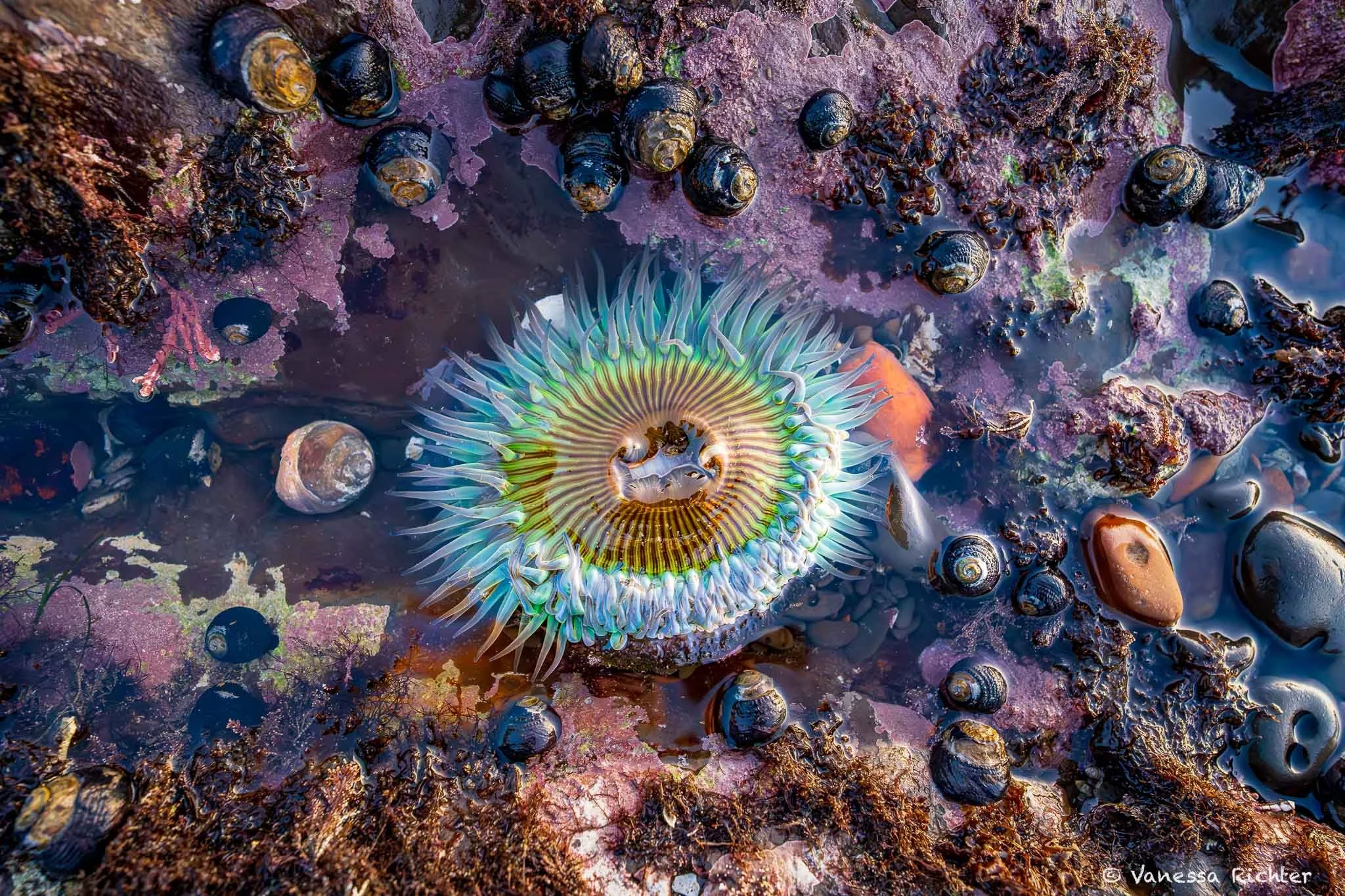
A sea anemone surrounded by mussels adds a burst of color to the rocky intertidal zone—look closely, and the tide pools left behind at low tide reveal a world full of life.
Duxbury Reef, located near Bolinas at the Southern end of Point Reyes is one of the largest shale reefs in North America and among the best tide pooling locations in California. The flat, rocky expanse is exposed during low tides and is home to an impressive variety of marine life — including several types of sea anemones, colorful nudibranchs, and even the occasional octopus.
🚗 Parking: Available at Agate Beach. Don’t enter “Duxbury Reef” into navigation apps—it may direct you to the wrong place.
🌊 What to Expect:
- Prime spot for tide pooling
- Large, flat, shallow shale reef — best explored at minus tides
- Short trail leads down from the bluff to the reef area
- Fewer sea stars due to the lack of vertical rock habitat
🦀 Best For Seeing:
- Moonglow, stubby rose, aggregating, and giant green anemones
- Seagrass, kelp, snails, and Cancer crabs
- Nudibranchs and (with luck) Pacific octopus
⚠️ Safety Note: Head back toward the shore before the tide starts to rise again — the flat terrain floods quickly and can trap you far from shore.
📈 Tide Chart: Tide Chart for Bolinas (Bolinas Lagoon)
🔗 More Info: CA Dept. of Fish & Wildlife: Duxbury Reef
Santa Maria Beach | Sculptured Beach (Hiking required)

Santa Maria Beach and its southern extension toward Sculptured Beach offer a remote and scenic tide pooling experience at Point Reyes. These beaches are only accessible by hike. While Duxbury Reef (see above for details) is the absolute prime location for tide pooling, this spot is a great destination if you’re looking to combine tide pooling with a hike or short backpacking adventure.
One of the best access points is via the Laguna Trail → Fire Lane Trail → Coast Trail (approximately 2.5 miles one way). The tide pools are best explored during a minus tide and are especially rewarding when paired with an overnight stay at Coast Campground (camping reservations required).
🚗 Parking: Park at Limantour Beach or Laguna Trailhead to start your hike to the beach (see link below for more info).
⛺ Camping: Coast Campground (backpacking only) is nearby and provides access to both Santa Maria and Sculptured Beach. Book via Recreation.gov
🌊 What to Expect:
- Hike-in required: remote beach with dramatic sandstone formations and sculpted rocks
- Tide pools appear near the southern end of Santa Maria Beach at minus tides
- Far fewer visitors than other spots — great for solitude and photography
🦀 Best For Seeing:
- Ochre sea stars (most common), sea anemones (aggregating, giant green), limpets, mussels, barnacles, and various crabs
- Occasional: bat stars, sunburst anemones, and nudibranchs
- Beautiful sea-carved textures and colors in the rock — especially great at sunset
⚠️ Safety Note: Access to Sculptured Beach is tide-dependent and can become impassable except at minus tides. Watch for sneaker waves and wet, slippery rocks.
📈 Tide Chart: Tide Chart for Point Reyes National Seashore
🔗 More Info: NPS: Hike to Sculptured Beach
Tide Pooling Essentials
Timing & How
- Tide pooling is only possible at low tide when receding water reveals ocean life usually submerged underwater.
- I recommend visiting 1–2 hours before the lowest tide. This timing allows ample time to explore while the tide is still receding, without worrying about incoming water.
- Marine life can be found in puddles or on rock surfaces. Different areas of the intertidal zones are home to different species. Sea anemones and sea stars often hide in the shade, so crouch down and look towards the bottom of rocks to spot them.
Explore & Contribute: iNaturalist
- iNaturalist is a fantastic resource to explore local tide pooling sightings.
- Search for particular species or get a full overview of marine life others have spotted in a particular area.
- Contribute your own observations via the app or website and help build community science data that supports conservation efforts.
Guidelines for Responsible & Safe Tide Pooling
- Walk gently and avoid stepping on rocks that host marine life, including small organisms like mussels.
- Respect wildlife and habitats by not removing or touching anything in tide pools or on rock surfaces. Disturbing these habitats can cause irreversible damage or stress to marine life.
- Avoid turning over rocks, as this disturbs the marine life living underneath.
- Watch for incoming tides to avoid getting stranded. The difference between low and high tide can be several feet, submerging areas accessible during low tide.
- Observe wet vs. dry areas to gauge where water reaches at high tide.
- Rocks can be extremely slippery. Wear shoes with good grip.
Favorite Hikes at Point Reyes
🥾 Essential Day Hiking Gear I Rely On
After years of trial and error, I’ve finally found hiking shoes that work across almost all terrains, a backpack that actually keeps my back cool, and a hydration setup that stays lightweight without sacrificing comfort. Plus, all the small things that make a hike noticeably more enjoyable. I’ve put everything together—from core essentials to the camera gear I rely on out on the trail.
→ See What I Actually Pack for Every HikeAlamere Falls via Palomarin Trailhead, Coastal Trail & Ocean Lake Loop
📍 Distance: ~13 mi (20.8 km) round trip
⛰ Elevation Gain: ~1,784 ft (543.8 m)
🔙 Route Type: Out & Back (for the most part, including a small loop section)
What makes this a great hike?
Alamere Falls is one of only two major waterfalls in California that flow directly into the Pacific Ocean (called a tidefall). The hike to Alamere Falls (if you go the proper way, which I recommend) is long, and absolutely magnificent, not just because of the waterfall, but also for its coastal views along the way, including views of lakes, the waterfall and the rugged shoreline all at once!
What route is the best one to Alamere Falls?
There are several options to hike out to Alamere Falls. I highly recommend starting at the Palomarin Trailhead and following the Coastal Trail. You can stay on this trail all the way to the Wildcat campground, from where you’ll have to hike another mile along the beach to reach Alamere Falls (IMPORTANT: read below how to plan for this stretch, which is only possible at LOW tide), which is what we did on the way in. But on the return trip, or both ways if you’re up for it, don’t miss the Ocean Lake Loop Trail. In this stretch, it brings you closer to the cliffside than the parallel Coastal Trail and offers some of the most phenomenal views of the entire route, with lakes, ocean, dramatic coastline and even Alamere Falls in the distance all at once.
Note: I strongly advise against taking the unofficial shortcut to the waterfall. It is not an official trail that comes with negative ecological impact, safety concerns and you will also miss out on some of the best views this hike has to offer.
What to keep in mind before heading out? Why Alamere Falls is not always accessible!
The beach portion of the trail is cut off by the ocean except at low tide. There’s a very narrow section close to the falls, so check the tide schedule for the lowest tide of the day and plan to hike that stretch while the tide is still receding. Even if the tide looks low, heading out when it's rising isn't a good idea — the beach narrows quickly in spots, and it’s easy to get caught. It’s roughly one mile each way along the beach, and with several especially tight sections near the ocean, there’s a real risk of getting trapped.
How to make the most of this hike?
The best way to experience it, in my view, is to secure a camping permit for Wildcat campground and make it a backpacking trip. This way, you don’t need to rush through it and have better chances and less stress for timing the beach part when the tide is low.
Looking for all the details? I have an in-depth article on this hike for you:

Tomales Point Trail
📍 Distance: 9.5 mi (15.2 km)
⛰ Elevation Gain: 1,200 ft (365.8 m)
🔙 Route Type: Out & Back
What makes this a great hike?
Tomales Point offers amazing opportunities for wildlife viewing, in particular tule elk at the tule elk reserve that you’ll pass along the way, but it is also great for birdwatching or seeing coyotes. You’ll also have amazing coastal views on a clear day.
What if I only want to see the elks?
The Tule Elk Reserve, where the elks typically rather is about halfway. If you only hike to that point it is around 4.8 miles total (~2 hours).
What to keep in mind before heading out?
Bring all the layers! You’ll very exposed to the elements on this hike as you are hiking on a peninsula right at the Pacific ocean, so it may be windy and, especially in summer, extremely foggy (read more below in Know Before You Go).
Looking To Get A Better Sense Of The Trail Vibes? Check Out Below:
Chimney Rock & Elephant Seal Overlook
📍 Distance: 2.3 mi (3.7 km)
⛰ Elevation Gain: ~206 ft (63 m)
🔁 Route Type: Out & Back
What makes this a great hike?
The hike around Chimney Rock is not long, but super rewarding! Depending on the time of year, you’ll be able to see elephant seals, whales from the tip of the peninsula, a large variety of birds and beautiful wildflowers. And, of course, amazing coastal views!
For wildflowers, go in the spring around April. For more info on wildlife, check out the sections on whales, birds and northern elephant seals to see what to expect during different seasons.
What to keep in mind before heading out?
As for Tomales Point, bring all the layers (read more below in Know Before You Go).
I’d recommend going early for this hike as the parking lot is super small and the last stretch of the road is narrow with just one lane, so arriving at the peak of visitor activity may be stressful.
A secluded beach visible while hiking the bluffs around Chimney Rock. Keep an eye out for elephant seals along the trail—they are more plentiful in some spots, but may appear on any of the beaches.
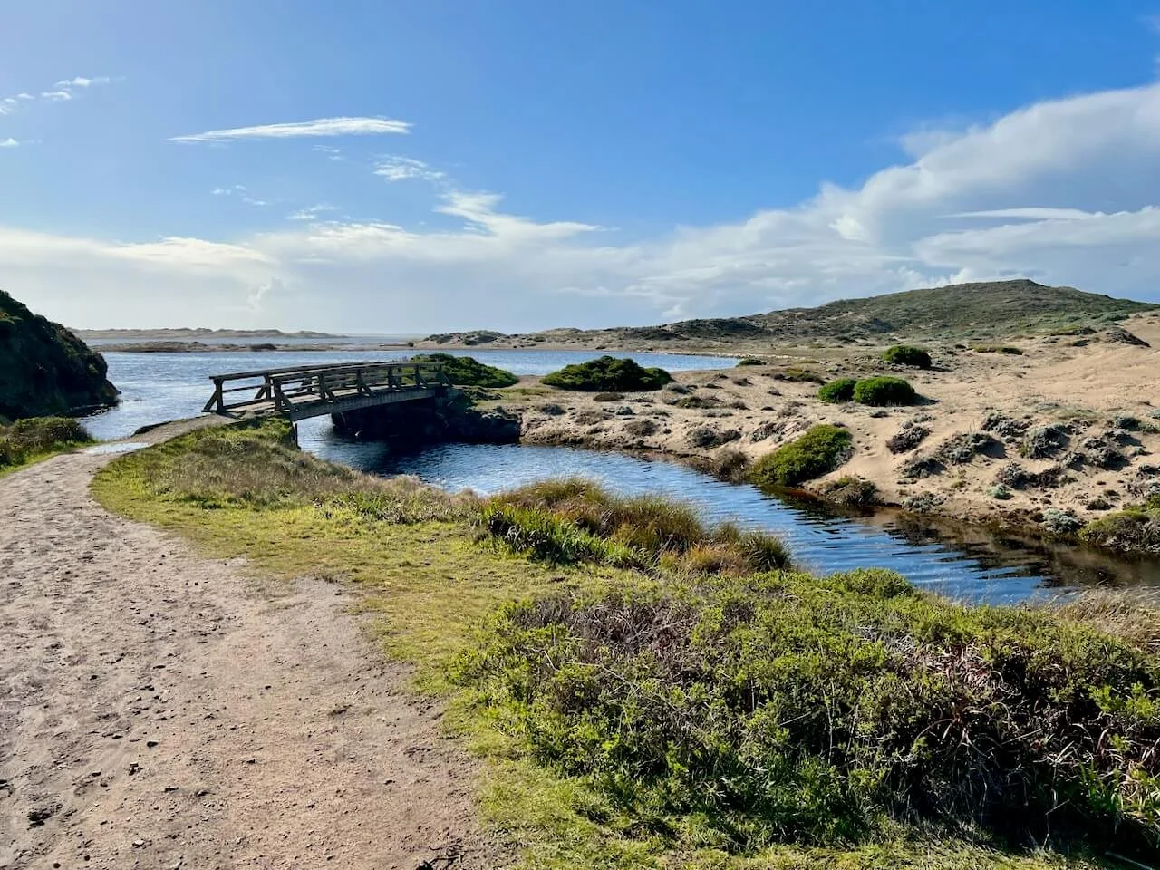
Abbotts Lagoon
📍 Distance: 3.2 mi (5.1 km)
⛰ Elevation Gain: ~150 ft (46 m)
🔁 Route Type: Out & Back
What makes this a great hike?
Abbotts Lagoon offers a chance to explore two lagoons separated by a footbridge, along with sand dunes and coastal views. It’s a prime spot for birdwatching, from migrating shorebirds in the fall to wintering ducks and raptors.
What to keep in mind before heading out
The threatened western snowy plover nests in the dunes at Abbotts Lagoon. Their eggs are fragile, so stay on designated paths and avoid disturbing nesting areas. Nesting season typically runs from March through September.
Bear Valley Trails
The Bear Valley Visitor Center is the main visitor center of Point Reyes. Starting from here, there are several great trails and two that are short, but particularly informative:
Earthquake Trail
📍 Distance: ~0.6 mi (1.0 km) loop
⛰ Elevation Gain: ~36 ft (11 m)
🔄 Route Type: Loop
What makes this a great hike?
The Earthquake Trail is a fascinating walk if you want to see the power of the San Andreas Fault up close. The fault itself is mostly hidden beneath vegetation, but its effects are clear along the trail. At one spot, a staircase is flanked by fences—on one side, the fence hugs the stairs closely, while on the other, it sits much farther away. This dramatic shift? A result of the 1906 earthquake, which moved the land by several meters!
This walk isn’t about visually dramatic landscapes, but standing there and imagining the earth literally moving beneath your feet is truly fascinating. Along the trail, informational signs explain the geology and history of the fault, helping you understand the slow but constant shifting of the plates beneath Point Reyes.
Woodpecker Trail
📍 Distance: ~0.9–1.0 mi (1.5–1.6 km) loop
⛰ Elevation Gain: ~100 ft (30 m)
🔄 Route Type: Loop
📄 Trail Guide: NPS Woodpecker Trail Guide
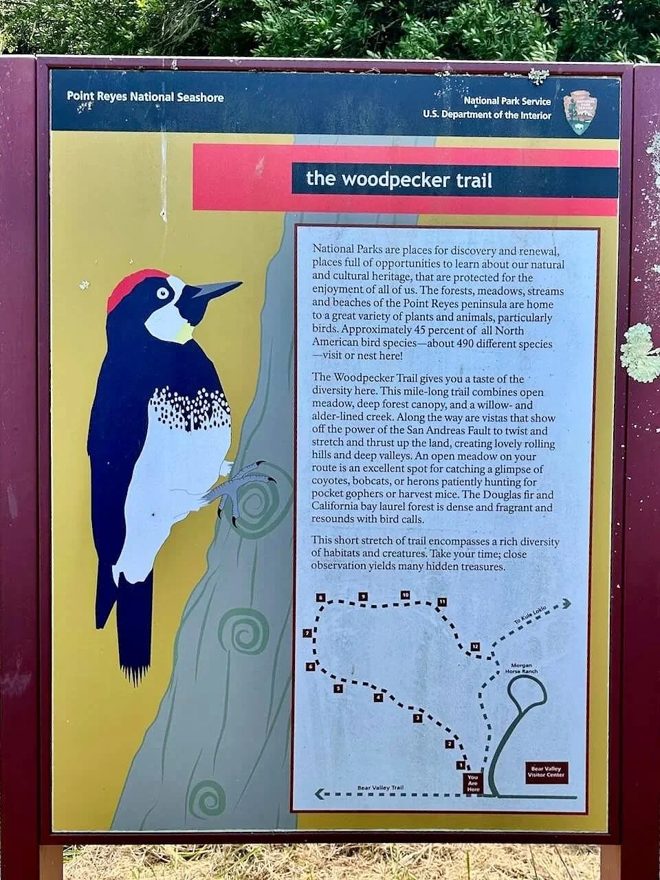
What makes this a great hike?
The Woodpecker Trail is a fantastic short hike for anyone wanting to learn more about the habitats and wildlife of Point Reyes.
Along the trail, stations highlight different natural features—grab the trail guide at the trailhead or at the Bear Valley Visitor Center to help you explore. Some features may be subtle, making this a perfect opportunity to slow down, observe carefully, and take it all in.
Best Places To Stay
⛺️ Campgrounds
All campgrounds within Point Reyes National Seashore are hike-in (or boat-in, see more here) only, require a reservation, and offer potable water, food storage lockers, and vault toilets. Charcoal grills (permanently removed in 2022) and showers are not available.
Coast Campground
- Easy access to Santa Maria Beach (220 yards) and tide pools (~720 yards southeast toward Sculptured Beach).
- Shortest way in is via the 1.8-mile slightly uphill hike on the Laguna & Fire Lane Trails, starting at the Laguna Trailhead.
- 12 regular sites & 2 group sites.
Sky Campground
- Located on the western side of Mount Wittenberg at an elevation of 1025 feet with views of Point Reyes, Drakes Bay, and the Pacific Ocean (when the sky is clear).
- Steep 4-mile hike down to the beach.
- Easiest and shortest approach is a 1.4-mile moderate uphill hike from the Sky Trailhead via Sky Trail.
- 11 regular sites & 1 group site.
Wildcat Campground
- Situated in a spacious meadow atop a bluff with panoramic ocean views and a brief stroll to the beach.
- 6.3-mile hike from Bear Valley Trailhead or 5.5-mile hike from the Palomarin Trailhead.
- 5 regular sites & 3 group sites.
Glen Campground
- Located deep within a wooded valley, with the closest beach being 2.5 miles away.
- Shortest route is from the Bear Valley Trailhead via a 4.6-mile hike.
- No groups (7+ people), horses, or pack animals allowed.
- 12 regular campsites.
Olema Campground (Outside Park Boundaries)
- Located in Olema, just outside the official boundaries of Point Reyes National Seashore.
- One of the closest car-accessible campgrounds to the park.
- Offers tent and RV sites, hot showers, potable water, and restrooms.
- Convenient base for exploring Point Reyes without the need to backpack.
🏠 Hotels & Vacation Rentals
Point Reyes National Seashore has no on-site hotels or drive-up campgrounds within the park boundaries, but there are a few nearby towns with cute hotels, motels, or vacation rentals:
- Inverness: A scenic small town along Tomales Bay. Known for beautiful bay views, boutique inns, kayaking, and oyster farms. Ideal for exploring Tomales Bay, with quick access to many parts of the Seashore. The closest town to the northern part of Point Reyes, including Tomales Point and Chimney Rock.
- Point Reyes Station: Along with Inverness, offers the best access to many parts of Point Reyes, especially the more remote northern areas. A charming small-town vibe with local cafes and shops.
- Olema: Another option just outside the park boundary. Offers cozy inns and bed & breakfasts. Slightly farther from the northern part of Point Reyes than Inverness or Point Reyes Station, but closest to the Bear Valley area.
- Bolinas: A quiet, artsy coastal town south of Point Reyes. Popular with surfers. Best for accessing the southern parts of Point Reyes, including trails to Alamere Falls and tide pooling at Duxbury Reef, which can be accessed through Agate Beach right in Bolinas.
- Stinson Beach: About a 20–30 minute drive from the southern end of Point Reyes.
*Affiliate links. I get a small kickback if you make a purchase through them, at no extra cost to you.
Know Before You Go
Best Time to Visit
- Spring (March–May): Hills are green and wildflowers bloom. Gray whale migration season, best time to see mothers and calves!
- Summer (June–August): Expect cool, foggy days and a thick marine layer. Don't expect warm summer days. Dress in layers and plan for limited sun and views. Humpback whale season!
- Fall (September–October): Like spring, fall often brings clearer skies, warmer temps, and active wildlife like rutting elk and coyotes. Still time to see humpback whales feeding.
- Winter (November–February): On dry days, winter offers crisp, clear air and revived greenery. Elephant seal pupping and gray whale migration season!
Visitor Centers & Access
- Bear Valley Visitor Center: The main visitor center. Check out the park store with a great selection of books and other things. Explore the exhibitions on natural and cultural history.
- Kenneth C. Patrick Visitor Center: Located at Drakes Beach, enjoy marine and elephant seal exhibits here.
- Parking at trailheads is usually fine but some lots can fill quickly (please see info on individual trails) on busy weekends.
Leave No Trace
- Stay on designated trails to protect fragile habitats and prevent erosion.
- Pack out all trash, leftover food, and recyclables.
- Observe wildlife from a distance; never feed animals.
- Learn more about the official Leave No Trace Principles.
I hope you enjoyed this article — by a real human for real humans. If you liked this guide, you can help me continue creating free resources like it.
Support