Best Hikes Near Moab: Essential Trails & Hidden Gems in Arches, Canyonlands & Beyond
This post contains affiliate links. If you book through them, I may earn a small commission at no extra cost to you — thank you for supporting this blog.
Moab is a hiker’s, adventure seeker’s, and desert lover’s paradise. From here, you can easily reach two iconic national parks — Arches and Canyonlands — but there are also plenty of incredible hikes outside the parks. This region is exactly what many people imagine when they think of Utah.
While Moab is close to famous trails like Delicate Arch, you’ll also find hidden gems where you can enjoy some peace and solitude.
In this guide, I’ll share my top hiking recommendations in the Moab area — both within and beyond the national parks.
In a Nutshell: What to Expect from This Guide?
- You are looking for hikes that require 20 minutes to an hour of driving from Moab to the trailhead.
- You are interested in a selection of hikes within the national parks (Canyonlands & Arches National Parks) as well as outside the park boundaries.
- The focus here is on mostly shorter hikes that can be done on an afternoon or morning to avoid the heat. One day hike is included though (Devil’s Garden).
If that all sounds good to you, settle in, grab a cup of coffee, tea, or whatever you need to get cozy, and let’s get started!
Essential Hike: Delicate Arch Trail (Arches National Park)
📍 Distance: 3.2 mi (5.1 km)
⛰ Elevation Gain: 629 ft (191.7 m)
🔙 Route Type: Out & Back
Okay—one disclaimer first: I am absolutely not the person for crowds and will happily skip a ‘major attraction’ if I think a place is overrun. Having said that, YES delicate arch is super popular and arguably the most famous arch in the park—possibly even in the world, but still I think this is an absolute must-see.
Delicate Arch, standing at 52 feet (16 m) tall, has become an iconic symbol of Utah, even appearing on the state’s license plates. Its freestanding structure and dramatic backdrop of the La Sal Mountains make it one of the most photographed natural landmarks in the United States, and it is truly simply beautiful to see this massive arch perched atop the landscape.
To make your experience better, I’d recommend going early or late — especially early morning, which can be incredibly helpful (even essential) to beat the midday heat.
Even though this trail sees a lot of visitors, we still managed to find a quiet spot with an amazing view of the arch, where we could just enjoy the spectacle of people lining up for their photos from a peaceful distance. When we visited in late May, the trail didn’t feel overcrowded in the late afternoon (we timed our hike to be back around sunset).
I’d also love to return for a night hike to photograph Delicate Arch under the Milky Way. If anyone has done this, I’d really appreciate it if you could share your experience in the comments below!
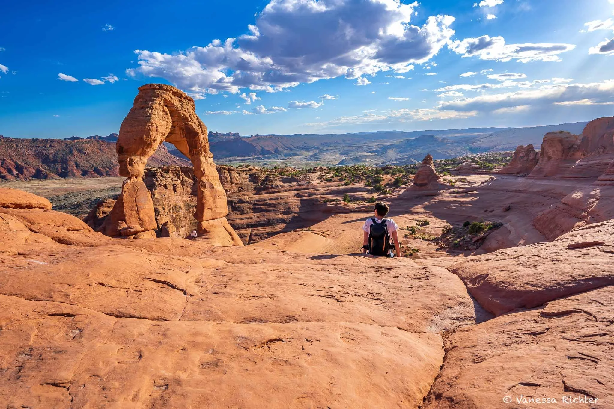
This picture definitely shows how the angle of a photo can be so deceiving. There were so many people at this spot, but it looks like we had it all to ourselves.

A peek through delicate arch, framing the distant snow-capped mountains.
Favorite Day Hike: Devils Garden Trail (Arches National Park)
📍 Distance: 7.9 mi (12.7 km)
⛰ Elevation Gain: 1,085 ft (330.7 m)
🔙 Route Type: Out & Back
For a longer hike with stunning arches and fewer crowds the farther you go, the Devils Garden Trail is an excellent choice. The first part of the trail leads to the iconic Landscape Arch, one of the park's most famous formations, and the longest natural arch in North America, stretching an incredible 306 feet (93.4 m)*.
While the area around Landscape Arch can be busy, it’s absolutely worth the visit. Its fragile structure means it could collapse at any time. In fact, several large slabs of rock fell from the arch in the 1990s, prompting the closure of the trail beneath it for safety reasons. Today, visitors can only admire it from a designated viewing area, making it all the more special to see while it still stands.
Beyond Landscape Arch, the Devils Garden Trail continues to more breathtaking arch formations, and the further you hike, the fewer people you’ll encounter, making this one of the most rewarding trails in Arches National Park.
In the second half of the hike, be prepared for some scrambling on slickrock and occasional exposure to heights. While it’s nothing super extreme, it does require caution and should be avoided entirely when the rock is wet or icy. I also highly recommend downloading trail navigation before heading out. We had some difficulty finding the trail at one point, and without navigation, continuing the hike would have been quite challenging—we might have ended up turning back instead.
This hike isn’t for those seeking a leisurely "walk in the park," but if you’re up for some adventure, you’ll be rewarded with a stunning variety of uniquely shaped arches and breathtaking views with more solitude.
*I found varying numbers, but this is the one provided by the National Park Service.🥾 Desert Hiking Demands the Right Gear
Desert trails are unforgiving — exposed sun, extreme heat, zero shade, and terrain that can shift from hardpacked rock to loose scree without warning. Hydration is everything out here, and I never head out without a full (water) bladder. I've put together a full list of what I bring: the lightweight shoes that handle technical desert terrain, the pack with ventilation that actually makes a difference in the heat, eco-conscious sun protection, and the small things that I genuinely wouldn't leave without.
→ Explore My Tried-and-True Hiking Gear


Stunning red rock formations rise along the Devil’s Garden Trail, framed by majestic snow-capped mountains in the distance.
Best Sunset Hike: White Rim Overlook Trail (Canyonlands National Park, Island in the Sky District)
📍 Distance: 1.8 mi (2.9 km)
⛰ Elevation Gain: 174 ft (53 m)
🔙 Route Type: Out & Back
The White Rim Overlook Trail is short and easy, and absolutely worth it. Just under 2 miles round trip, this mostly flat walk leads to one of the most stunning canyon views in Canyonlands. You’ll see the Colorado River, Monument Basin, and the La Sal Mountains in the distance, all layered in scenery reminiscent of the Grand Canyon.
I recommend starting in the late afternoon. Sunset here is simply magical: the canyon walls glow gold and orange, the river catches the light, and the La Sals turn purple as the sun dips. It’s usually quieter than other overlooks too. Don’t forget a headlamp if you’re lingering after dark.

The sky was literally on fire, and this place actually reminded us a lot of the Grand Canyon.
Best Geologic Wonder Hike: Upheaval Dome via Crater View Trail (Canyonlands National Park, Island in the Sky District)
📍 Distance: 1.3 mi (2.1 km)
⛰ Elevation Gain: 226 ft (69 m)
🔙 Route Type: Out & Back
“Canyonlands is a place of relative geologic order. Layers of sedimentary deposits systematically record chapters in the park's past. With some exceptions, these layers have not been altered, tilted or folded significantly in the millions of years since they were laid down by ancient seas, rivers or winds.
Upheaval Dome is quite a different story. In an area approximately three miles (5 km) across, rock layers are dramatically deformed. In the center, the rocks are pushed up into a circular structure called a dome, or an anticline. Surrounding this dome is a downwarp in the rock layers called a syncline.”
The Upheaval Dome Overlook Trail takes you to a unique geological formation: a mile-wide crater that was long shrouded in mystery, and it is still not entirely certain what caused it. As you hike, you’ll notice how the rocks tilt away from the dome, a stark contrast to the surrounding landscape shaped by gradual erosion. So, what caused this anomaly? Theories include a meteorite strike 60 million years ago, and the salt dome theory.

Corona & Bowtie Arch Trail (Outside National Parks)
📍 Distance: 2.3 miles (3.7 km)
⛰ Elevation Gain: 463 ft (141 m)
🔙 Route Type: Out & Back
If you're looking to see arches without the heavy crowds of Arches National Park, or you couldn’t snag a park reservation, the surrounding area offers great alternatives. One of my favorite hikes is the trail to the stunning Bowtie and Corona Arches, located outside the park.
The Corona Arch stands an impressive 105 ft (32 m) tall, making it twice the height of the iconic Delicate Arch, which is 52 ft (16 m) tall. Standing beneath Corona Arch, you'll feel tiny — and look like an ant from a distance (see the second picture below: I’m actually standing under the arch with my hands in the air, but I’m barely visible)
While this trail is generally less crowded than those within Arches National Park, it’s still popular, especially on weekends during the peak seasons (spring and fall). The pictures below were taken on a late afternoon midweek in late May, when we had the arches to ourselves for about 30 minutes. So you can absolutely find some solitude on this trail at the right time!
Do note that this trail briefly exposes you to heights. There is a small section of the trail that includes ladders and safety cables. Nothing crazy though, in my view (and I’m a rather cautious person).


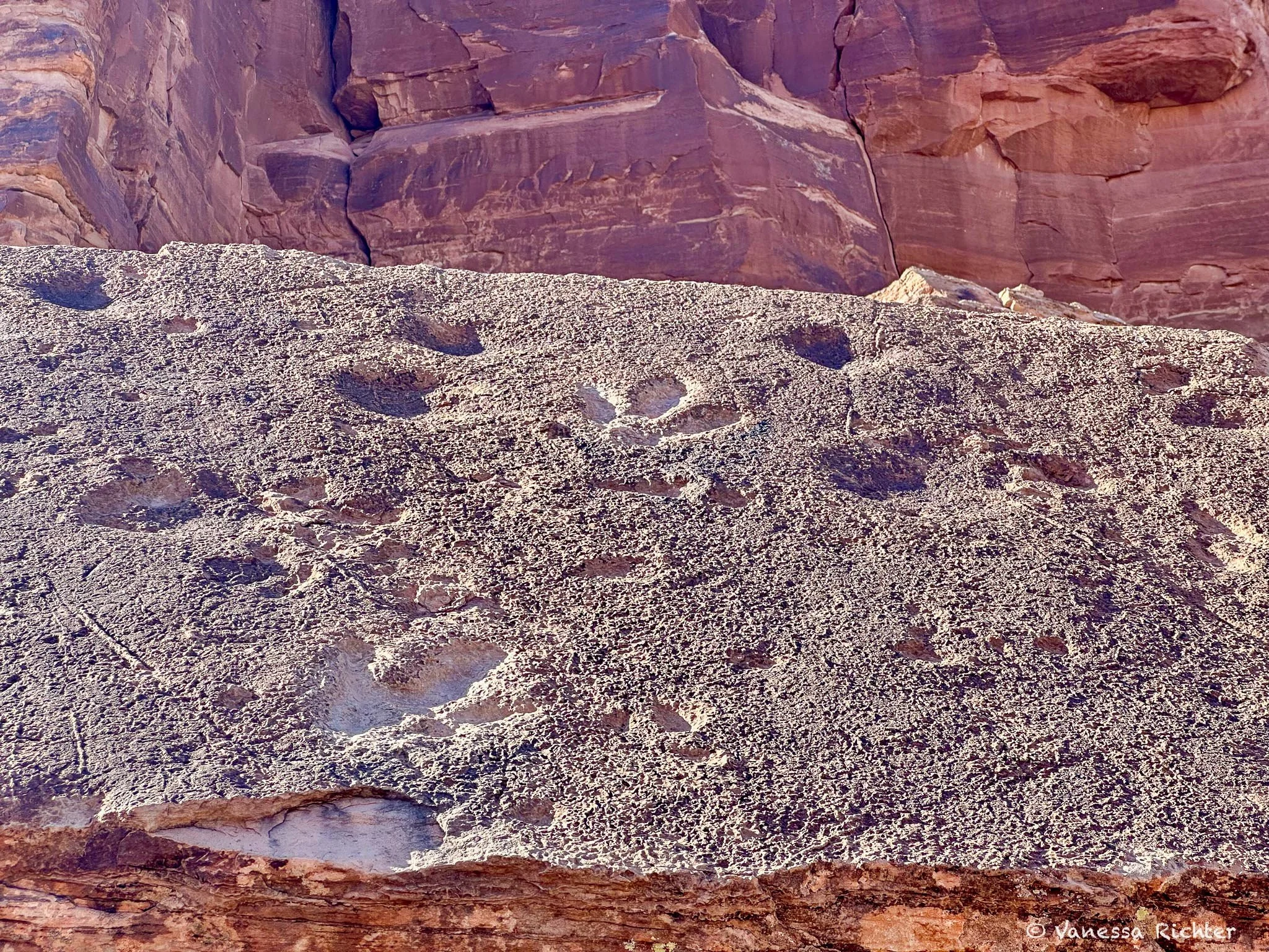
Poison Spider Dinosaur Tracksite Trail (outside National Parks)
📍 Distance: 0.2 miles (0.32 km)
⛰ Elevation Gain: 82 ft (25 m)
🔙 Route Type: Out & Back
This tiny trail is barely 0.2 miles, and more a scramble up slickrock, but it’s so much more than it sounds.
It will bring you face-to-face with actual fossilized dinosaur footprints pressed into the rock roughly 150 million years ago, alongside ancient petroglyphs left by Indigenous peoples long before any of us were wandering these canyons with hiking boots and water bottles.
There's something quietly surreal about standing on a sun-baked ledge in the Utah desert, looking down at a footprint made by a creature that roamed this same landscape during the Jurassic period.
The whole scramble takes about 15 minutes, and since it sits right on the highway between Moab and the Corona Arch trailhead, there's genuinely no reason to skip it (except if you are afraid of heights maybe). Tack it on at the start or end of your Corona and Bowtie Arch hike.

Where to Stay
Moab offers a fantastic range of accommodation options, from cozy downtown hotels and motels to unique vacation rentals and campgrounds surrounded by stunning red rock landscapes.
We stayed in a vacation rental a bit outside of central Moab, which gave us a peaceful retreat after busy days exploring the parks while still being just a short drive from town and main attractions.
- Downtown Moab: Perfect if you want to be close to restaurants, shops, and activities. It’s walkable and lively, ideal for those who enjoy having everything nearby.
- Vacation Rentals Outside Town: Great for more privacy, space, and often stunning views.
- Camping: There are many campgrounds in and around Moab, including those inside Arches and Canyonlands National Parks, as well as RV parks and dispersed camping areas.
Know Before You Go
Fees & Access
- Park Fees: Entrance is $30 per vehicle for the national parks (Arches and Canyonlands). If you're visiting both, the America the Beautiful Pass ($80/year) is a great deal and also covers other national parks like nearby Capitol Reef and Bryce Canyon.
- No Timed-Entry for Arches: In 2026, timed-entry reservations are not required to enter the park.
- No Timed-Entry for Canyonlands: Canyonlands does not require reservations, but Island in the Sky (the most accessible section of Canyonlands) can still get busy at certain times. When we visited in late May, the trails weren’t crowded at all — definitely much, much quieter than Arches!
Best Time to Visit
- Spring (March–May): Best time to visit! Wildflowers bloom, and temperatures are mild. Bring layers — mornings can be chilly!
- Summer (June–August): Scorching hot — expect 100°F+ midday temps. Hike only at sunrise and sunset. Stay hydrated and avoid exposed trails during peak heat.
- Fall (September–October): Another ideal window: pleasant temps, golden cottonwoods, and vivid sunsets. Reservations are still required at Arches through October.
- Winter (November–February): Cold, but quiet and stunning. Snow dusting the red rocks is a dream for photographers. Some trails may be icy, so check conditions before heading out. No timed entry needed in winter.
Safety
- Heat & Hydration: Carry more water than you think you’ll need. There is no water available on most trails!
- Start Early (ideally) or Late: This ties in with the previous point: desert heat builds quickly. Most trails have little to no shade — morning hikes are safer and far more pleasant. Late afternoon works well too — but if it gets really hot during the day, late afternoons/evenings are still warmer than early mornings.
- Flash Floods: Slot canyons and washes can flood quickly during storms, even if it’s not raining overhead. Always check the forecast.
- Navigation: Some trails are marked by cairns and can be hard to follow. Most of the trails mentioned here are totally fine, I’d say — only on the second half of the Devils Garden Trail, we might have considered turning around without an offline map. There was one spot with a bit of scrambling on slickrock where a map really helped to find the trail.
Find More Adventures Near Moab
Follow the Adventure
Latest on the Blog

Search
📌 Pin for later
I’m the writer and photographer behind Venture Beyond the Picture.
You're in the right place if you're looking for nature-focused guides, real tales from the trails, and photography that celebrates wild landscapes. I'm especially drawn to the quieter, equally fascinating details in nature that are easy to miss, and to digging into the ecological story of a place. You'll find a range of easy-to-scan travel guides, deep dives, stories from my favorite hiking trails, and the occasional science-y exploration of the latest research on ecological topics.